You are here: Home > Network List > US - United States National Seismic Network Stations List
> Station HAWA Hanford, Washington, USA > Earthquake Result Viewer
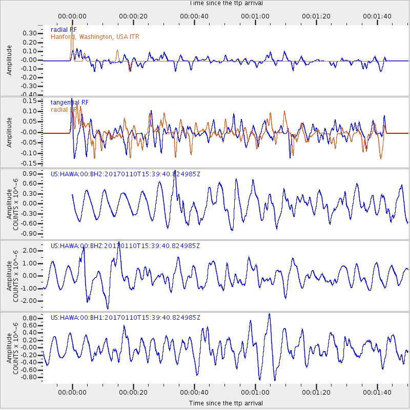
HAWA Hanford, Washington, USA - Earthquake Result Viewer
*The percent match for this event was below the threshold and hence no stack was calculated.
| Earthquake location: |
Solomon Islands |
| Earthquake latitude/longitude: |
-10.1/161.0 |
| Earthquake time(UTC): |
2017/01/10 (010) 15:27:15 GMT |
| Earthquake Depth: |
28 km |
| Earthquake Magnitude: |
6.3 Mww |
| Earthquake Catalog/Contributor: |
NEIC PDE/us |
|
| Network: |
US United States National Seismic Network |
| Station: |
HAWA Hanford, Washington, USA |
| Lat/Lon: |
46.39 N/119.53 W |
| Elevation: |
364 m |
|
| Distance: |
90.1 deg |
| Az: |
42.876 deg |
| Baz: |
255.45 deg |
| Ray Param: |
$rayparam |
*The percent match for this event was below the threshold and hence was not used in the summary stack. |
|
| Radial Match: |
65.817345 % |
| Radial Bump: |
400 |
| Transverse Match: |
59.234215 % |
| Transverse Bump: |
400 |
| SOD ConfigId: |
1943534 |
| Insert Time: |
2017-01-24 15:29:29.800 +0000 |
| GWidth: |
2.5 |
| Max Bumps: |
400 |
| Tol: |
0.001 |
|
Signal To Noise
| Channel | StoN | STA | LTA |
| US:HAWA:00:BHZ:20170110T15:39:40.824985Z | 2.3891246 | 1.102001E-6 | 4.6125723E-7 |
| US:HAWA:00:BH1:20170110T15:39:40.824985Z | 0.832232 | 2.3578951E-7 | 2.8332187E-7 |
| US:HAWA:00:BH2:20170110T15:39:40.824985Z | 1.880113 | 5.219416E-7 | 2.7761183E-7 |
| Arrivals |
| Ps | |
| PpPs | |
| PsPs/PpSs | |


