You are here: Home > Network List > CI - Caltech Regional Seismic Network Stations List
> Station MPM Manuel Prospect Mine, California, USA > Earthquake Result Viewer
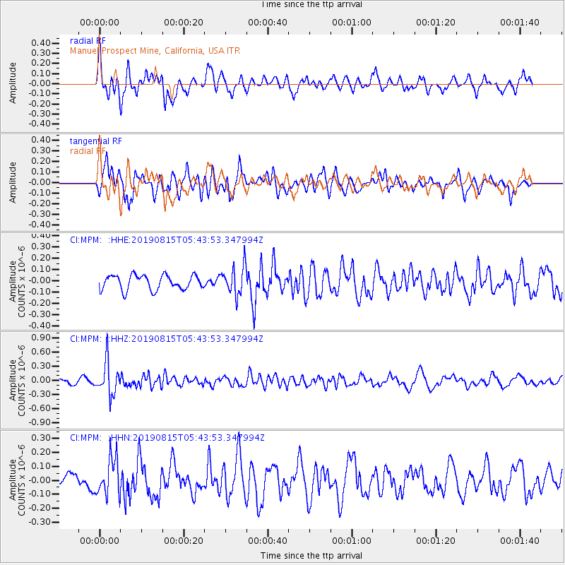
MPM Manuel Prospect Mine, California, USA - Earthquake Result Viewer
*The percent match for this event was below the threshold and hence no stack was calculated.
| Earthquake location: |
Near East Coast Of Honshu, Japan |
| Earthquake latitude/longitude: |
40.8/141.2 |
| Earthquake time(UTC): |
2019/08/15 (227) 05:32:53 GMT |
| Earthquake Depth: |
86 km |
| Earthquake Magnitude: |
5.4 Mww |
| Earthquake Catalog/Contributor: |
NEIC PDE/us |
|
| Network: |
CI Caltech Regional Seismic Network |
| Station: |
MPM Manuel Prospect Mine, California, USA |
| Lat/Lon: |
36.06 N/117.49 W |
| Elevation: |
185 m |
|
| Distance: |
74.8 deg |
| Az: |
55.42 deg |
| Baz: |
309.551 deg |
| Ray Param: |
$rayparam |
*The percent match for this event was below the threshold and hence was not used in the summary stack. |
|
| Radial Match: |
58.121758 % |
| Radial Bump: |
400 |
| Transverse Match: |
70.05988 % |
| Transverse Bump: |
400 |
| SOD ConfigId: |
19053131 |
| Insert Time: |
2019-09-12 06:39:37.877 +0000 |
| GWidth: |
2.5 |
| Max Bumps: |
400 |
| Tol: |
0.001 |
|
Signal To Noise
| Channel | StoN | STA | LTA |
| CI:MPM: :HHZ:20190815T05:43:53.347994Z | 4.957314 | 3.454903E-7 | 6.9693044E-8 |
| CI:MPM: :HHN:20190815T05:43:53.347994Z | 1.8481998 | 1.3312393E-7 | 7.202897E-8 |
| CI:MPM: :HHE:20190815T05:43:53.347994Z | 2.0087118 | 1.29725E-7 | 6.4581194E-8 |
| Arrivals |
| Ps | |
| PpPs | |
| PsPs/PpSs | |


