You are here: Home > Network List > TA - USArray Transportable Network (new EarthScope stations) Stations List
> Station J07A Hines, OR, USA > Earthquake Result Viewer
J07A Hines, OR, USA - Earthquake Result Viewer
| Earthquake location: |
Windward Islands |
| Earthquake latitude/longitude: |
15.0/-61.3 |
| Earthquake time(UTC): |
2007/11/29 (333) 19:00:19 GMT |
| Earthquake Depth: |
148 km |
| Earthquake Magnitude: |
6.9 MB, 7.4 MW, 7.4 MW |
| Earthquake Catalog/Contributor: |
WHDF/NEIC |
|
| Network: |
TA USArray Transportable Network (new EarthScope stations) |
| Station: |
J07A Hines, OR, USA |
| Lat/Lon: |
43.37 N/119.31 W |
| Elevation: |
1273 m |
|
| Distance: |
56.7 deg |
| Az: |
312.265 deg |
| Baz: |
101.228 deg |
| Ray Param: |
0.06348591 |
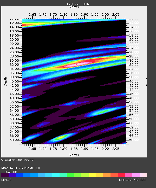
| Estimated Moho Depth: |
31.75 km |
| Estimated Crust Vp/Vs: |
1.86 |
| Assumed Crust Vp: |
6.279 km/s |
| Estimated Crust Vs: |
3.376 km/s |
| Estimated Crust Poisson's Ratio: |
0.30 |
|
| Radial Match: |
90.72952 % |
| Radial Bump: |
400 |
| Transverse Match: |
86.34814 % |
| Transverse Bump: |
400 |
| SOD ConfigId: |
2564 |
| Insert Time: |
2010-03-07 03:51:12.948 +0000 |
| GWidth: |
2.5 |
| Max Bumps: |
400 |
| Tol: |
0.001 |
|

Signal To Noise
| Channel | StoN | STA | LTA |
| TA:J07A: :BHN:20071129T19:09:17.300024Z | 4.2477503 | 1.872697E-6 | 4.4086798E-7 |
| TA:J07A: :BHE:20071129T19:09:17.300024Z | 14.299332 | 5.8779997E-6 | 4.1106813E-7 |
| TA:J07A: :BHZ:20071129T19:09:17.300024Z | 27.6277 | 1.0008701E-5 | 3.622705E-7 |
| Arrivals |
| Ps | 4.5 SECOND |
| PpPs | 14 SECOND |
| PsPs/PpSs | 18 SECOND |


