You are here: Home > Network List > TA - USArray Transportable Network (new EarthScope stations) Stations List
> Station J07A Hines, OR, USA > Earthquake Result Viewer
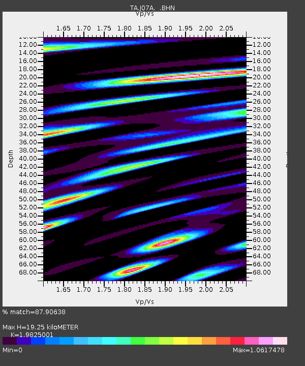
J07A Hines, OR, USA - Earthquake Result Viewer
| Earthquake location: |
Mariana Islands |
| Earthquake latitude/longitude: |
18.9/145.4 |
| Earthquake time(UTC): |
2007/10/31 (304) 03:30:17 GMT |
| Earthquake Depth: |
223 km |
| Earthquake Magnitude: |
6.2 MB, 7.2 MW, 7.2 MW |
| Earthquake Catalog/Contributor: |
WHDF/NEIC |
|
| Network: |
TA USArray Transportable Network (new EarthScope stations) |
| Station: |
J07A Hines, OR, USA |
| Lat/Lon: |
43.37 N/119.31 W |
| Elevation: |
1273 m |
|
| Distance: |
81.0 deg |
| Az: |
47.313 deg |
| Baz: |
287.37 deg |
| Ray Param: |
0.047317345 |
| Estimated Moho Depth: |
19.25 km |
| Estimated Crust Vp/Vs: |
1.98 |
| Assumed Crust Vp: |
6.279 km/s |
| Estimated Crust Vs: |
3.167 km/s |
| Estimated Crust Poisson's Ratio: |
0.33 |
|
| Radial Match: |
87.90638 % |
| Radial Bump: |
400 |
| Transverse Match: |
79.72374 % |
| Transverse Bump: |
400 |
| SOD ConfigId: |
2564 |
| Insert Time: |
2010-03-07 03:51:19.365 +0000 |
| GWidth: |
2.5 |
| Max Bumps: |
400 |
| Tol: |
0.001 |
|

Signal To Noise
| Channel | StoN | STA | LTA |
| TA:J07A: :BHN:20071031T03:41:36.250027Z | 1.7677306 | 7.165603E-7 | 4.0535605E-7 |
| TA:J07A: :BHE:20071031T03:41:36.250027Z | 5.654895 | 1.9290949E-6 | 3.4113717E-7 |
| TA:J07A: :BHZ:20071031T03:41:36.250027Z | 21.014227 | 4.9277496E-6 | 2.3449589E-7 |
| Arrivals |
| Ps | 3.1 SECOND |
| PpPs | 8.9 SECOND |
| PsPs/PpSs | 12 SECOND |


