You are here: Home > Network List > TA - USArray Transportable Network (new EarthScope stations) Stations List
> Station J07A Hines, OR, USA > Earthquake Result Viewer
J07A Hines, OR, USA - Earthquake Result Viewer
| Earthquake location: |
Tonga Islands |
| Earthquake latitude/longitude: |
-17.5/-174.3 |
| Earthquake time(UTC): |
2007/08/26 (238) 12:37:31 GMT |
| Earthquake Depth: |
127 km |
| Earthquake Magnitude: |
5.9 MB, 6.1 MW |
| Earthquake Catalog/Contributor: |
WHDF/NEIC |
|
| Network: |
TA USArray Transportable Network (new EarthScope stations) |
| Station: |
J07A Hines, OR, USA |
| Lat/Lon: |
43.37 N/119.31 W |
| Elevation: |
1273 m |
|
| Distance: |
78.8 deg |
| Az: |
37.53 deg |
| Baz: |
232.885 deg |
| Ray Param: |
0.049124584 |
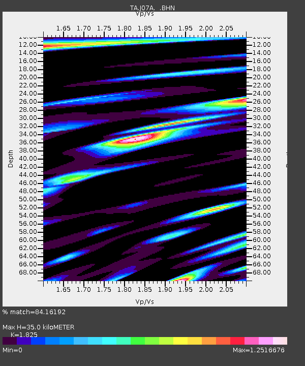
| Estimated Moho Depth: |
35.0 km |
| Estimated Crust Vp/Vs: |
1.83 |
| Assumed Crust Vp: |
6.279 km/s |
| Estimated Crust Vs: |
3.44 km/s |
| Estimated Crust Poisson's Ratio: |
0.29 |
|
| Radial Match: |
84.16192 % |
| Radial Bump: |
368 |
| Transverse Match: |
82.129776 % |
| Transverse Bump: |
342 |
| SOD ConfigId: |
2564 |
| Insert Time: |
2010-03-07 03:51:34.595 +0000 |
| GWidth: |
2.5 |
| Max Bumps: |
400 |
| Tol: |
0.001 |
|

Signal To Noise
| Channel | StoN | STA | LTA |
| TA:J07A: :BHN:20070826T12:48:48.674009Z | 1.6250166 | 2.6403256E-7 | 1.6247994E-7 |
| TA:J07A: :BHE:20070826T12:48:48.674009Z | 3.2172306 | 4.0842508E-7 | 1.2694927E-7 |
| TA:J07A: :BHZ:20070826T12:48:48.674009Z | 15.287966 | 1.1150983E-6 | 7.2939606E-8 |
| Arrivals |
| Ps | 4.7 SECOND |
| PpPs | 15 SECOND |
| PsPs/PpSs | 20 SECOND |


