You are here: Home > Network List > TS - TERRAscope (Southern California Seismic Network) Stations List
> Station MLAC Mammoth Lakes, California, USA > Earthquake Result Viewer
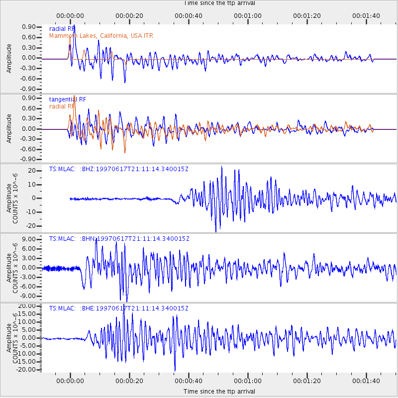
MLAC Mammoth Lakes, California, USA - Earthquake Result Viewer
*The percent match for this event was below the threshold and hence no stack was calculated.
| Earthquake location: |
Andreanof Islands, Aleutian Is. |
| Earthquake latitude/longitude: |
51.3/-179.3 |
| Earthquake time(UTC): |
1997/06/17 (168) 21:03:40 GMT |
| Earthquake Depth: |
33 km |
| Earthquake Magnitude: |
6.4 MB, 6.3 MS, 6.4 UNKNOWN, 6.6 ML |
| Earthquake Catalog/Contributor: |
WHDF/NEIC |
|
| Network: |
TS TERRAscope (Southern California Seismic Network) |
| Station: |
MLAC Mammoth Lakes, California, USA |
| Lat/Lon: |
37.63 N/118.83 W |
| Elevation: |
2170 m |
|
| Distance: |
44.0 deg |
| Az: |
83.659 deg |
| Baz: |
308.27 deg |
| Ray Param: |
$rayparam |
*The percent match for this event was below the threshold and hence was not used in the summary stack. |
|
| Radial Match: |
65.98801 % |
| Radial Bump: |
400 |
| Transverse Match: |
69.79968 % |
| Transverse Bump: |
400 |
| SOD ConfigId: |
4480 |
| Insert Time: |
2010-02-26 14:27:27.747 +0000 |
| GWidth: |
2.5 |
| Max Bumps: |
400 |
| Tol: |
0.001 |
|
Signal To Noise
| Channel | StoN | STA | LTA |
| TS:MLAC: :BHN:19970617T21:11:14.340015Z | 5.031842 | 2.3144644E-6 | 4.599636E-7 |
| TS:MLAC: :BHE:19970617T21:11:14.340015Z | 0.8248602 | 2.8699674E-7 | 3.479338E-7 |
| TS:MLAC: :BHZ:19970617T21:11:14.340015Z | 1.5350157 | 4.3842465E-7 | 2.8561573E-7 |
| Arrivals |
| Ps | |
| PpPs | |
| PsPs/PpSs | |


