You are here: Home > Network List > TA - USArray Transportable Network (new EarthScope stations) Stations List
> Station J07A Hines, OR, USA > Earthquake Result Viewer
J07A Hines, OR, USA - Earthquake Result Viewer
| Earthquake location: |
Solomon Islands |
| Earthquake latitude/longitude: |
-9.8/159.5 |
| Earthquake time(UTC): |
2007/08/16 (228) 08:39:27 GMT |
| Earthquake Depth: |
10 km |
| Earthquake Magnitude: |
6.1 MB, 6.7 MS, 6.4 MW |
| Earthquake Catalog/Contributor: |
WHDF/NEIC |
|
| Network: |
TA USArray Transportable Network (new EarthScope stations) |
| Station: |
J07A Hines, OR, USA |
| Lat/Lon: |
43.37 N/119.31 W |
| Elevation: |
1273 m |
|
| Distance: |
90.4 deg |
| Az: |
46.109 deg |
| Baz: |
256.903 deg |
| Ray Param: |
0.04167842 |
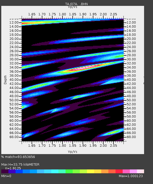
| Estimated Moho Depth: |
33.75 km |
| Estimated Crust Vp/Vs: |
1.91 |
| Assumed Crust Vp: |
6.279 km/s |
| Estimated Crust Vs: |
3.283 km/s |
| Estimated Crust Poisson's Ratio: |
0.31 |
|
| Radial Match: |
93.653656 % |
| Radial Bump: |
400 |
| Transverse Match: |
86.22475 % |
| Transverse Bump: |
400 |
| SOD ConfigId: |
2564 |
| Insert Time: |
2010-03-07 03:51:37.662 +0000 |
| GWidth: |
2.5 |
| Max Bumps: |
400 |
| Tol: |
0.001 |
|

Signal To Noise
| Channel | StoN | STA | LTA |
| TA:J07A: :BHN:20070816T08:51:57.325027Z | 0.5336803 | 5.2471748E-8 | 9.832056E-8 |
| TA:J07A: :BHE:20070816T08:51:57.325027Z | 1.6161153 | 1.5314907E-7 | 9.4763706E-8 |
| TA:J07A: :BHZ:20070816T08:51:57.325027Z | 7.7361794 | 3.9439027E-7 | 5.097998E-8 |
| Arrivals |
| Ps | 5.0 SECOND |
| PpPs | 15 SECOND |
| PsPs/PpSs | 20 SECOND |


