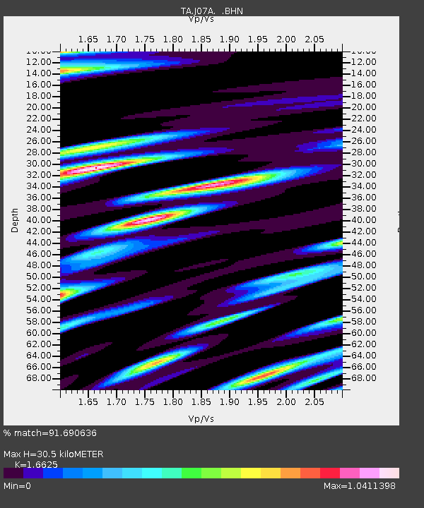
J07A Hines, OR, USA - Earthquake Result Viewer

Earthquake location: Andreanof Islands, Aleutian Is.
Earthquake latitude/longitude: 50.3/-177.5
Earthquake time(UTC): 2007/08/15 (227) 20:22:11 GMT
Earthquake Depth: 9.0 km
Earthquake Magnitude: 6.3 MB, 6.2 MS, 6.4 MW, 5.9 ML
Earthquake Catalog/Contributor: WHDF/NEIC
Network: TA USArray Transportable Network (new EarthScope stations)
Station: J07A Hines, OR, USA
Lat/Lon: 43.37 N/119.31 W
Elevation: 1273 m
Distance: 39.5 deg
Az: 76.921 deg
Baz: 301.1 deg
Ray Param: 0.07493304
Estimated Moho Depth: 30.5 km
Estimated Crust Vp/Vs: 1.66
Assumed Crust Vp: 6.279 km/s
Estimated Crust Vs: 3.777 km/s
Estimated Crust Poisson's Ratio: 0.22
Radial Match: 91.690636 %
Radial Bump: 400
Transverse Match: 78.12296 %
Transverse Bump: 400
SOD ConfigId: 2564
Insert Time: 2010-03-07 03:51:40.355 +0000
GWidth: 2.5
Max Bumps: 400
Tol: 0.001

Signal To Noise

ChannelStoNSTALTA
TA:J07A: :BHN:20070815T20:29:11.350011Z7.02343941.0568482E-61.5047445E-7
TA:J07A: :BHE:20070815T20:29:11.350011Z8.9840681.4385625E-61.6012373E-7
TA:J07A: :BHZ:20070815T20:29:11.350011Z39.829082.988584E-67.5035224E-8
Arrivals
Ps3.5 SECOND
PpPs12 SECOND
PsPs/PpSs15 SECOND