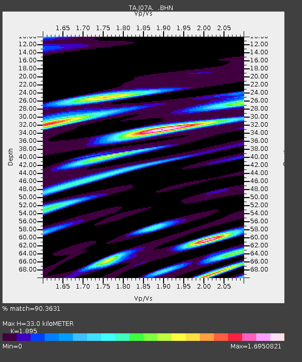
J07A Hines, OR, USA - Earthquake Result Viewer
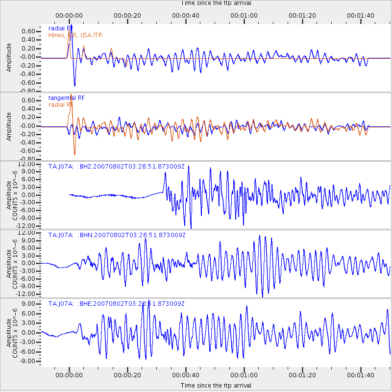
Earthquake location: Andreanof Islands, Aleutian Is.
Earthquake latitude/longitude: 51.3/-180.0
Earthquake time(UTC): 2007/08/02 (214) 03:21:42 GMT
Earthquake Depth: 21 km
Earthquake Magnitude: 6.3 MB, 6.6 MS, 6.7 MW, 6.6 MW
Earthquake Catalog/Contributor: WHDF/NEIC
Network: TA USArray Transportable Network (new EarthScope stations)
Station: J07A Hines, OR, USA
Lat/Lon: 43.37 N/119.31 W
Elevation: 1273 m
Distance: 40.8 deg
Az: 76.602 deg
Baz: 303.134 deg
Ray Param: 0.074156985
Estimated Moho Depth: 33.0 km
Estimated Crust Vp/Vs: 1.89
Assumed Crust Vp: 6.279 km/s
Estimated Crust Vs: 3.313 km/s
Estimated Crust Poisson's Ratio: 0.31
Radial Match: 90.3631 %
Radial Bump: 388
Transverse Match: 79.23551 %
Transverse Bump: 400
SOD ConfigId: 2564
Insert Time: 2010-03-07 03:51:42.319 +0000
GWidth: 2.5
Max Bumps: 400
Tol: 0.001

Signal To Noise

ChannelStoNSTALTA
TA:J07A: :BHN:20070802T03:28:51.873009Z3.2106879.366879E-72.9174066E-7
TA:J07A: :BHE:20070802T03:28:51.873009Z2.05724621.280864E-66.226109E-7
TA:J07A: :BHZ:20070802T03:28:51.873009Z7.7093073.0545066E-63.9621028E-7
Arrivals
Ps5.0 SECOND
PpPs14 SECOND
PsPs/PpSs19 SECOND