You are here: Home > Network List > TA - USArray Transportable Network (new EarthScope stations) Stations List
> Station G26K Porcupine River, AK, USA > Earthquake Result Viewer
G26K Porcupine River, AK, USA - Earthquake Result Viewer
| Earthquake location: |
Near East Coast Of Honshu, Japan |
| Earthquake latitude/longitude: |
40.8/141.2 |
| Earthquake time(UTC): |
2019/08/15 (227) 05:32:53 GMT |
| Earthquake Depth: |
86 km |
| Earthquake Magnitude: |
5.4 Mww |
| Earthquake Catalog/Contributor: |
NEIC PDE/us |
|
| Network: |
TA USArray Transportable Network (new EarthScope stations) |
| Station: |
G26K Porcupine River, AK, USA |
| Lat/Lon: |
66.95 N/143.78 W |
| Elevation: |
180 m |
|
| Distance: |
47.5 deg |
| Az: |
31.075 deg |
| Baz: |
275.887 deg |
| Ray Param: |
0.06970776 |
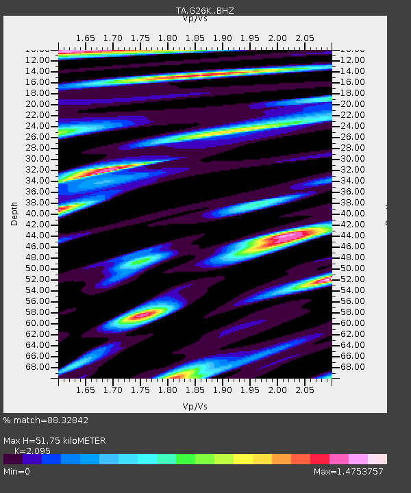
| Estimated Moho Depth: |
51.75 km |
| Estimated Crust Vp/Vs: |
2.10 |
| Assumed Crust Vp: |
6.577 km/s |
| Estimated Crust Vs: |
3.139 km/s |
| Estimated Crust Poisson's Ratio: |
0.35 |
|
| Radial Match: |
88.32842 % |
| Radial Bump: |
400 |
| Transverse Match: |
81.35377 % |
| Transverse Bump: |
400 |
| SOD ConfigId: |
19053131 |
| Insert Time: |
2019-09-12 06:45:49.568 +0000 |
| GWidth: |
2.5 |
| Max Bumps: |
400 |
| Tol: |
0.001 |
|

Signal To Noise
| Channel | StoN | STA | LTA |
| TA:G26K: :BHZ:20190815T05:40:48.750002Z | 12.438564 | 1.3469166E-6 | 1.0828554E-7 |
| TA:G26K: :BHN:20190815T05:40:48.750002Z | 5.450489 | 7.2077626E-7 | 1.3224066E-7 |
| TA:G26K: :BHE:20190815T05:40:48.750002Z | 8.072699 | 8.6571015E-7 | 1.07239245E-7 |
| Arrivals |
| Ps | 9.1 SECOND |
| PpPs | 23 SECOND |
| PsPs/PpSs | 32 SECOND |


