You are here: Home > Network List > TA - USArray Transportable Network (new EarthScope stations) Stations List
> Station H16K Elim, AK, USA > Earthquake Result Viewer
H16K Elim, AK, USA - Earthquake Result Viewer
| Earthquake location: |
Near East Coast Of Honshu, Japan |
| Earthquake latitude/longitude: |
40.8/141.2 |
| Earthquake time(UTC): |
2019/08/15 (227) 05:32:53 GMT |
| Earthquake Depth: |
86 km |
| Earthquake Magnitude: |
5.4 Mww |
| Earthquake Catalog/Contributor: |
NEIC PDE/us |
|
| Network: |
TA USArray Transportable Network (new EarthScope stations) |
| Station: |
H16K Elim, AK, USA |
| Lat/Lon: |
64.64 N/162.24 W |
| Elevation: |
216 m |
|
| Distance: |
39.8 deg |
| Az: |
34.122 deg |
| Baz: |
261.257 deg |
| Ray Param: |
0.074482605 |
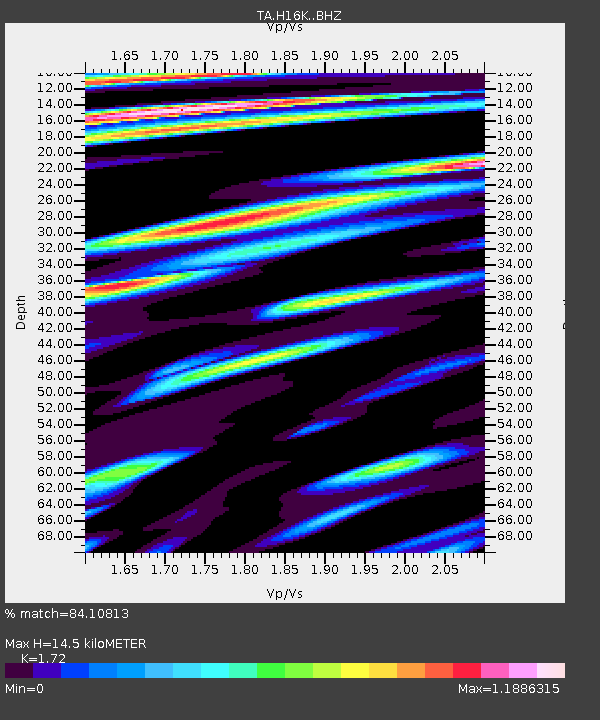
| Estimated Moho Depth: |
14.5 km |
| Estimated Crust Vp/Vs: |
1.72 |
| Assumed Crust Vp: |
6.276 km/s |
| Estimated Crust Vs: |
3.649 km/s |
| Estimated Crust Poisson's Ratio: |
0.24 |
|
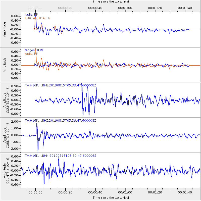
| Radial Match: |
84.10813 % |
| Radial Bump: |
400 |
| Transverse Match: |
66.19754 % |
| Transverse Bump: |
400 |
| SOD ConfigId: |
19053131 |
| Insert Time: |
2019-09-12 06:45:53.009 +0000 |
| GWidth: |
2.5 |
| Max Bumps: |
400 |
| Tol: |
0.001 |
|
Signal To Noise
| Channel | StoN | STA | LTA |
| TA:H16K: :BHZ:20190815T05:39:47.600008Z | 12.484146 | 8.4727617E-7 | 6.786817E-8 |
| TA:H16K: :BHN:20190815T05:39:47.600008Z | 1.6348702 | 1.3438945E-7 | 8.220191E-8 |
| TA:H16K: :BHE:20190815T05:39:47.600008Z | 5.964105 | 5.413317E-7 | 9.076495E-8 |
| Arrivals |
| Ps | 1.8 SECOND |
| PpPs | 5.9 SECOND |
| PsPs/PpSs | 7.6 SECOND |


