You are here: Home > Network List > TA - USArray Transportable Network (new EarthScope stations) Stations List
> Station H31M Peel River, Yukon, CAN > Earthquake Result Viewer
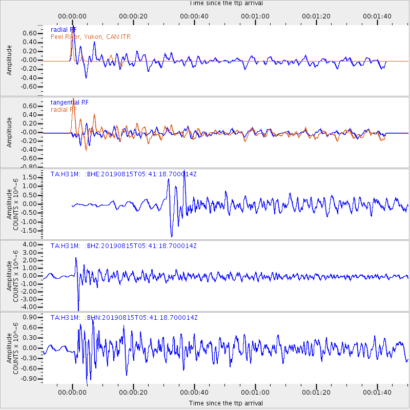
H31M Peel River, Yukon, CAN - Earthquake Result Viewer
*The percent match for this event was below the threshold and hence no stack was calculated.
| Earthquake location: |
Near East Coast Of Honshu, Japan |
| Earthquake latitude/longitude: |
40.8/141.2 |
| Earthquake time(UTC): |
2019/08/15 (227) 05:32:53 GMT |
| Earthquake Depth: |
86 km |
| Earthquake Magnitude: |
5.4 Mww |
| Earthquake Catalog/Contributor: |
NEIC PDE/us |
|
| Network: |
TA USArray Transportable Network (new EarthScope stations) |
| Station: |
H31M Peel River, Yukon, CAN |
| Lat/Lon: |
65.81 N/134.34 W |
| Elevation: |
642 m |
|
| Distance: |
51.4 deg |
| Az: |
31.656 deg |
| Baz: |
284.91 deg |
| Ray Param: |
$rayparam |
*The percent match for this event was below the threshold and hence was not used in the summary stack. |
|
| Radial Match: |
79.0413 % |
| Radial Bump: |
400 |
| Transverse Match: |
74.64003 % |
| Transverse Bump: |
400 |
| SOD ConfigId: |
19053131 |
| Insert Time: |
2019-09-12 06:46:00.529 +0000 |
| GWidth: |
2.5 |
| Max Bumps: |
400 |
| Tol: |
0.001 |
|
Signal To Noise
| Channel | StoN | STA | LTA |
| TA:H31M: :BHZ:20190815T05:41:18.700014Z | 8.212396 | 1.2540903E-6 | 1.52707E-7 |
| TA:H31M: :BHN:20190815T05:41:18.700014Z | 3.2894917 | 3.5469748E-7 | 1.0782744E-7 |
| TA:H31M: :BHE:20190815T05:41:18.700014Z | 6.824389 | 8.8224914E-7 | 1.2927885E-7 |
| Arrivals |
| Ps | |
| PpPs | |
| PsPs/PpSs | |


