You are here: Home > Network List > TA - USArray Transportable Network (new EarthScope stations) Stations List
> Station J17K VABM Dome, AK, USA > Earthquake Result Viewer
J17K VABM Dome, AK, USA - Earthquake Result Viewer
| Earthquake location: |
Near East Coast Of Honshu, Japan |
| Earthquake latitude/longitude: |
40.8/141.2 |
| Earthquake time(UTC): |
2019/08/15 (227) 05:32:53 GMT |
| Earthquake Depth: |
86 km |
| Earthquake Magnitude: |
5.4 Mww |
| Earthquake Catalog/Contributor: |
NEIC PDE/us |
|
| Network: |
TA USArray Transportable Network (new EarthScope stations) |
| Station: |
J17K VABM Dome, AK, USA |
| Lat/Lon: |
63.40 N/159.08 W |
| Elevation: |
323 m |
|
| Distance: |
41.1 deg |
| Az: |
36.274 deg |
| Baz: |
265.733 deg |
| Ray Param: |
0.07373775 |
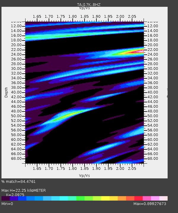
| Estimated Moho Depth: |
22.25 km |
| Estimated Crust Vp/Vs: |
2.10 |
| Assumed Crust Vp: |
6.276 km/s |
| Estimated Crust Vs: |
2.992 km/s |
| Estimated Crust Poisson's Ratio: |
0.35 |
|
| Radial Match: |
84.4761 % |
| Radial Bump: |
396 |
| Transverse Match: |
70.083176 % |
| Transverse Bump: |
400 |
| SOD ConfigId: |
19053131 |
| Insert Time: |
2019-09-12 06:46:08.448 +0000 |
| GWidth: |
2.5 |
| Max Bumps: |
400 |
| Tol: |
0.001 |
|

Signal To Noise
| Channel | StoN | STA | LTA |
| TA:J17K: :BHZ:20190815T05:39:57.825014Z | 16.155743 | 1.1631436E-6 | 7.199568E-8 |
| TA:J17K: :BHN:20190815T05:39:57.825014Z | 2.6888542 | 1.9964682E-7 | 7.4249776E-8 |
| TA:J17K: :BHE:20190815T05:39:57.825014Z | 11.640308 | 6.030182E-7 | 5.1804314E-8 |
| Arrivals |
| Ps | 4.1 SECOND |
| PpPs | 10 SECOND |
| PsPs/PpSs | 15 SECOND |


