You are here: Home > Network List > TA - USArray Transportable Network (new EarthScope stations) Stations List
> Station J07A Hines, OR, USA > Earthquake Result Viewer
J07A Hines, OR, USA - Earthquake Result Viewer
| Earthquake location: |
Kuril Islands |
| Earthquake latitude/longitude: |
46.6/153.3 |
| Earthquake time(UTC): |
2006/11/15 (319) 11:14:13 GMT |
| Earthquake Depth: |
10 km |
| Earthquake Magnitude: |
6.5 MB, 7.8 MS, 8.3 MW, 7.9 MW |
| Earthquake Catalog/Contributor: |
WHDF/NEIC |
|
| Network: |
TA USArray Transportable Network (new EarthScope stations) |
| Station: |
J07A Hines, OR, USA |
| Lat/Lon: |
43.37 N/119.31 W |
| Elevation: |
1273 m |
|
| Distance: |
58.8 deg |
| Az: |
58.398 deg |
| Baz: |
306.342 deg |
| Ray Param: |
0.062614426 |
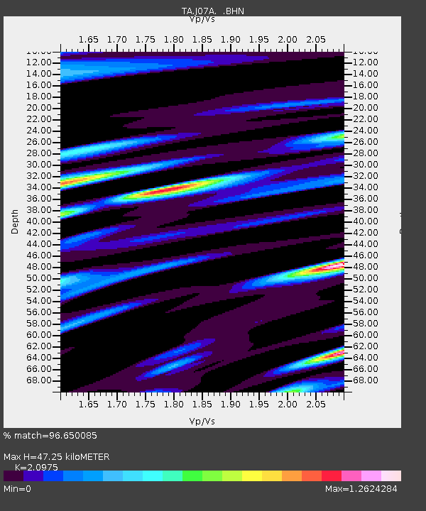
| Estimated Moho Depth: |
47.25 km |
| Estimated Crust Vp/Vs: |
2.10 |
| Assumed Crust Vp: |
6.279 km/s |
| Estimated Crust Vs: |
2.993 km/s |
| Estimated Crust Poisson's Ratio: |
0.35 |
|
| Radial Match: |
96.650085 % |
| Radial Bump: |
400 |
| Transverse Match: |
83.07083 % |
| Transverse Bump: |
400 |
| SOD ConfigId: |
2564 |
| Insert Time: |
2010-03-07 03:52:14.236 +0000 |
| GWidth: |
2.5 |
| Max Bumps: |
400 |
| Tol: |
0.001 |
|

Signal To Noise
| Channel | StoN | STA | LTA |
| TA:J07A: :BHN:20061115T11:23:40.775017Z | 1.3089643 | 6.639154E-7 | 5.072067E-7 |
| TA:J07A: :BHE:20061115T11:23:40.775017Z | 1.3303721 | 7.72134E-7 | 5.803895E-7 |
| TA:J07A: :BHZ:20061115T11:23:40.775017Z | 6.8304644 | 1.650659E-6 | 2.4166133E-7 |
| Arrivals |
| Ps | 8.6 SECOND |
| PpPs | 22 SECOND |
| PsPs/PpSs | 31 SECOND |


