You are here: Home > Network List > TA - USArray Transportable Network (new EarthScope stations) Stations List
> Station J07A Hines, OR, USA > Earthquake Result Viewer
J07A Hines, OR, USA - Earthquake Result Viewer
| Earthquake location: |
Sakhalin, Russia |
| Earthquake latitude/longitude: |
46.5/141.9 |
| Earthquake time(UTC): |
2006/08/17 (229) 15:20:35 GMT |
| Earthquake Depth: |
17 km |
| Earthquake Magnitude: |
6.0 MB, 5.2 MS, 5.6 MW, 5.5 MW |
| Earthquake Catalog/Contributor: |
WHDF/NEIC |
|
| Network: |
TA USArray Transportable Network (new EarthScope stations) |
| Station: |
J07A Hines, OR, USA |
| Lat/Lon: |
43.37 N/119.31 W |
| Elevation: |
1273 m |
|
| Distance: |
65.3 deg |
| Az: |
52.501 deg |
| Baz: |
311.32 deg |
| Ray Param: |
0.058364253 |
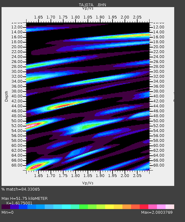
| Estimated Moho Depth: |
51.75 km |
| Estimated Crust Vp/Vs: |
1.62 |
| Assumed Crust Vp: |
6.279 km/s |
| Estimated Crust Vs: |
3.882 km/s |
| Estimated Crust Poisson's Ratio: |
0.19 |
|
| Radial Match: |
84.33065 % |
| Radial Bump: |
400 |
| Transverse Match: |
67.86765 % |
| Transverse Bump: |
400 |
| SOD ConfigId: |
2564 |
| Insert Time: |
2010-03-07 03:52:16.148 +0000 |
| GWidth: |
2.5 |
| Max Bumps: |
400 |
| Tol: |
0.001 |
|
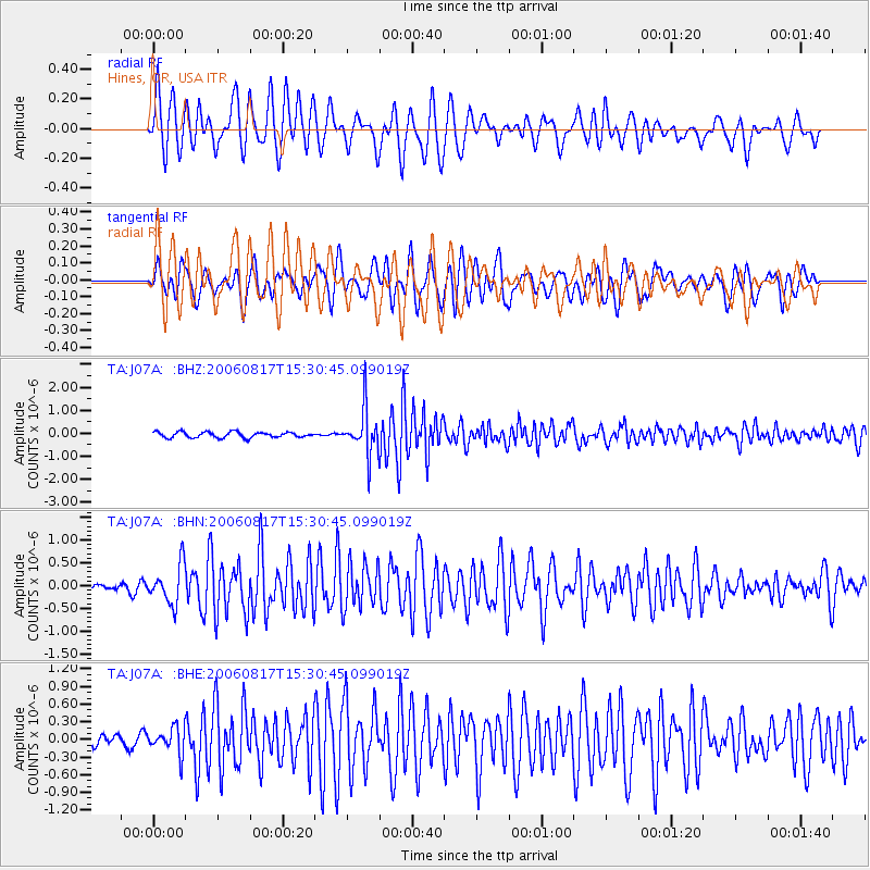
Signal To Noise
| Channel | StoN | STA | LTA |
| TA:J07A: :BHN:20060817T15:30:45.099019Z | 2.1315167 | 4.25853E-7 | 1.9978872E-7 |
| TA:J07A: :BHE:20060817T15:30:45.099019Z | 1.5913061 | 2.20355E-7 | 1.384743E-7 |
| TA:J07A: :BHZ:20060817T15:30:45.099019Z | 8.216122 | 9.961474E-7 | 1.2124302E-7 |
| Arrivals |
| Ps | 5.3 SECOND |
| PpPs | 21 SECOND |
| PsPs/PpSs | 26 SECOND |


