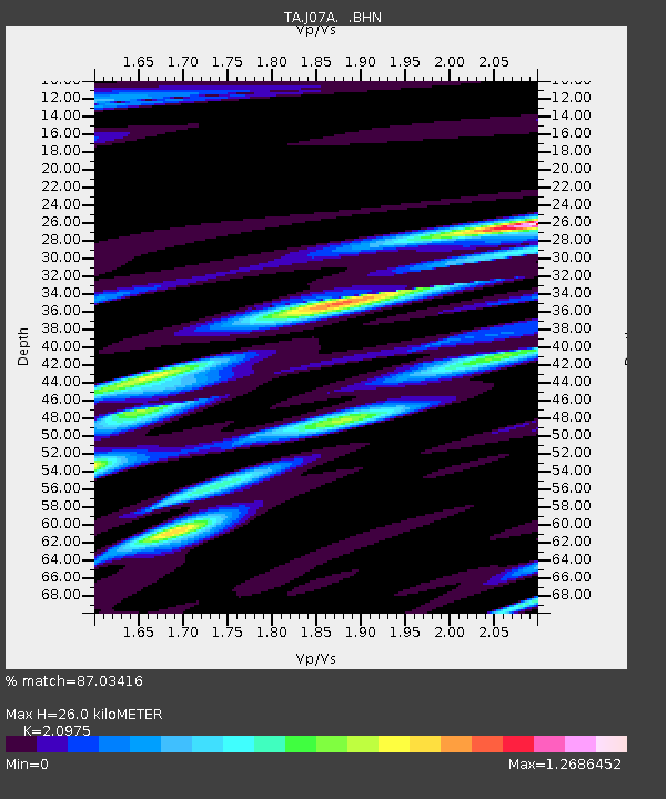
J07A Hines, OR, USA - Earthquake Result Viewer

Earthquake location: New Britain Region, P.N.G.
Earthquake latitude/longitude: -5.9/151.0
Earthquake time(UTC): 2006/10/17 (290) 01:25:12 GMT
Earthquake Depth: 32 km
Earthquake Magnitude: 6.4 MB, 6.9 MS, 6.7 MW, 6.6 MW
Earthquake Catalog/Contributor: WHDF/NEIC
Network: TA USArray Transportable Network (new EarthScope stations)
Station: J07A Hines, OR, USA
Lat/Lon: 43.37 N/119.31 W
Elevation: 1273 m
Distance: 93.8 deg
Az: 46.951 deg
Baz: 265.534 deg
Ray Param: 0.04118245
Estimated Moho Depth: 26.0 km
Estimated Crust Vp/Vs: 2.10
Assumed Crust Vp: 6.279 km/s
Estimated Crust Vs: 2.993 km/s
Estimated Crust Poisson's Ratio: 0.35
Radial Match: 87.03416 %
Radial Bump: 400
Transverse Match: 74.67245 %
Transverse Bump: 400
SOD ConfigId: 2665
Insert Time: 2010-03-07 03:52:20.471 +0000
GWidth: 2.5
Max Bumps: 400
Tol: 0.001

Signal To Noise

ChannelStoNSTALTA
TA:J07A: :BHN:20061017T01:37:54.62502Z0.493130032.7023978E-75.480092E-7
TA:J07A: :BHE:20061017T01:37:54.62502Z5.69177341.3570212E-62.38418E-7
TA:J07A: :BHZ:20061017T01:37:54.62502Z23.6686022.8460142E-61.202443E-7
Arrivals
Ps4.6 SECOND
PpPs13 SECOND
PsPs/PpSs17 SECOND