You are here: Home > Network List > TA - USArray Transportable Network (new EarthScope stations) Stations List
> Station O17K Koliganek, Bristol Bay, AK, USA > Earthquake Result Viewer
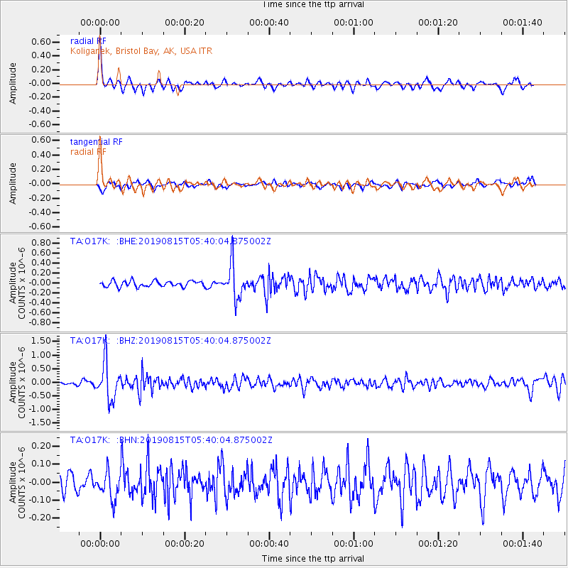
O17K Koliganek, Bristol Bay, AK, USA - Earthquake Result Viewer
| Earthquake location: |
Near East Coast Of Honshu, Japan |
| Earthquake latitude/longitude: |
40.8/141.2 |
| Earthquake time(UTC): |
2019/08/15 (227) 05:32:53 GMT |
| Earthquake Depth: |
86 km |
| Earthquake Magnitude: |
5.4 Mww |
| Earthquake Catalog/Contributor: |
NEIC PDE/us |
|
| Network: |
TA USArray Transportable Network (new EarthScope stations) |
| Station: |
O17K Koliganek, Bristol Bay, AK, USA |
| Lat/Lon: |
59.77 N/157.09 W |
| Elevation: |
156 m |
|
| Distance: |
41.9 deg |
| Az: |
41.795 deg |
| Baz: |
271.612 deg |
| Ray Param: |
0.0732055 |
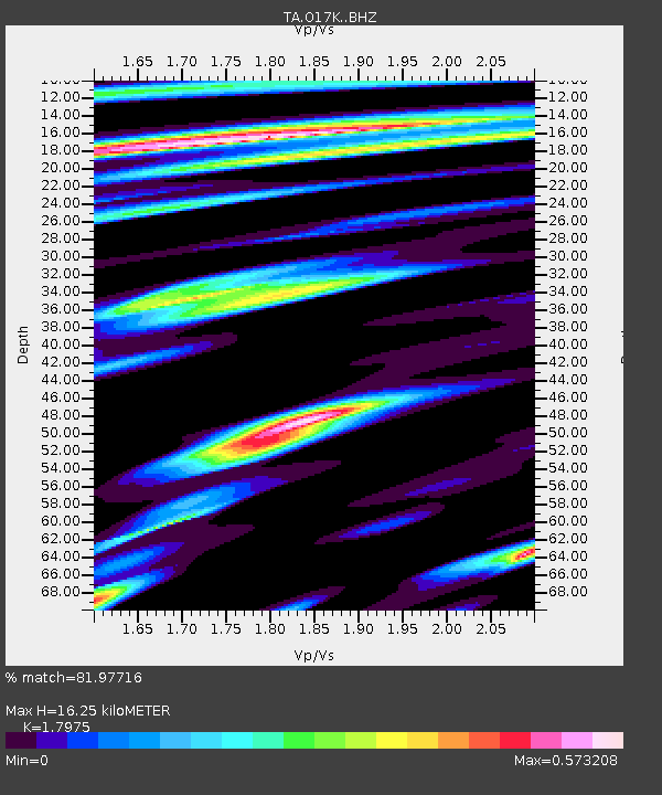
| Estimated Moho Depth: |
16.25 km |
| Estimated Crust Vp/Vs: |
1.80 |
| Assumed Crust Vp: |
6.276 km/s |
| Estimated Crust Vs: |
3.491 km/s |
| Estimated Crust Poisson's Ratio: |
0.28 |
|
| Radial Match: |
81.97716 % |
| Radial Bump: |
361 |
| Transverse Match: |
64.45431 % |
| Transverse Bump: |
400 |
| SOD ConfigId: |
19053131 |
| Insert Time: |
2019-09-12 06:46:43.083 +0000 |
| GWidth: |
2.5 |
| Max Bumps: |
400 |
| Tol: |
0.001 |
|
Signal To Noise
| Channel | StoN | STA | LTA |
| TA:O17K: :BHZ:20190815T05:40:04.875002Z | 12.770978 | 6.878288E-7 | 5.3858738E-8 |
| TA:O17K: :BHN:20190815T05:40:04.875002Z | 1.3985409 | 7.5564685E-8 | 5.4031087E-8 |
| TA:O17K: :BHE:20190815T05:40:04.875002Z | 6.1401544 | 3.5126754E-7 | 5.7208258E-8 |
| Arrivals |
| Ps | 2.2 SECOND |
| PpPs | 6.8 SECOND |
| PsPs/PpSs | 9.0 SECOND |


