You are here: Home > Network List > TA - USArray Transportable Network (new EarthScope stations) Stations List
> Station R33M Jennings River, BC, CAN > Earthquake Result Viewer
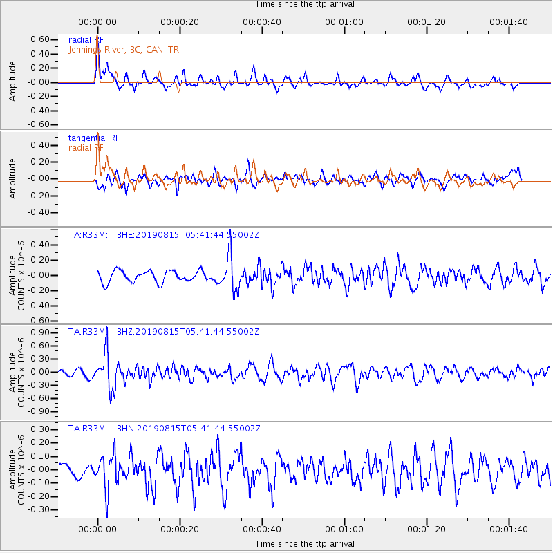
R33M Jennings River, BC, CAN - Earthquake Result Viewer
*The percent match for this event was below the threshold and hence no stack was calculated.
| Earthquake location: |
Near East Coast Of Honshu, Japan |
| Earthquake latitude/longitude: |
40.8/141.2 |
| Earthquake time(UTC): |
2019/08/15 (227) 05:32:53 GMT |
| Earthquake Depth: |
86 km |
| Earthquake Magnitude: |
5.4 Mww |
| Earthquake Catalog/Contributor: |
NEIC PDE/us |
|
| Network: |
TA USArray Transportable Network (new EarthScope stations) |
| Station: |
R33M Jennings River, BC, CAN |
| Lat/Lon: |
59.39 N/130.97 W |
| Elevation: |
1437 m |
|
| Distance: |
54.9 deg |
| Az: |
38.658 deg |
| Baz: |
292.11 deg |
| Ray Param: |
$rayparam |
*The percent match for this event was below the threshold and hence was not used in the summary stack. |
|
| Radial Match: |
69.45079 % |
| Radial Bump: |
400 |
| Transverse Match: |
56.116863 % |
| Transverse Bump: |
400 |
| SOD ConfigId: |
19053131 |
| Insert Time: |
2019-09-12 06:47:00.590 +0000 |
| GWidth: |
2.5 |
| Max Bumps: |
400 |
| Tol: |
0.001 |
|
Signal To Noise
| Channel | StoN | STA | LTA |
| TA:R33M: :BHZ:20190815T05:41:44.55002Z | 5.2214785 | 4.2894868E-7 | 8.2150805E-8 |
| TA:R33M: :BHN:20190815T05:41:44.55002Z | 1.676143 | 1.3246361E-7 | 7.902882E-8 |
| TA:R33M: :BHE:20190815T05:41:44.55002Z | 3.0908022 | 2.3047171E-7 | 7.4566955E-8 |
| Arrivals |
| Ps | |
| PpPs | |
| PsPs/PpSs | |


