You are here: Home > Network List > TA - USArray Transportable Network (new EarthScope stations) Stations List
> Station J07A Hines, OR, USA > Earthquake Result Viewer
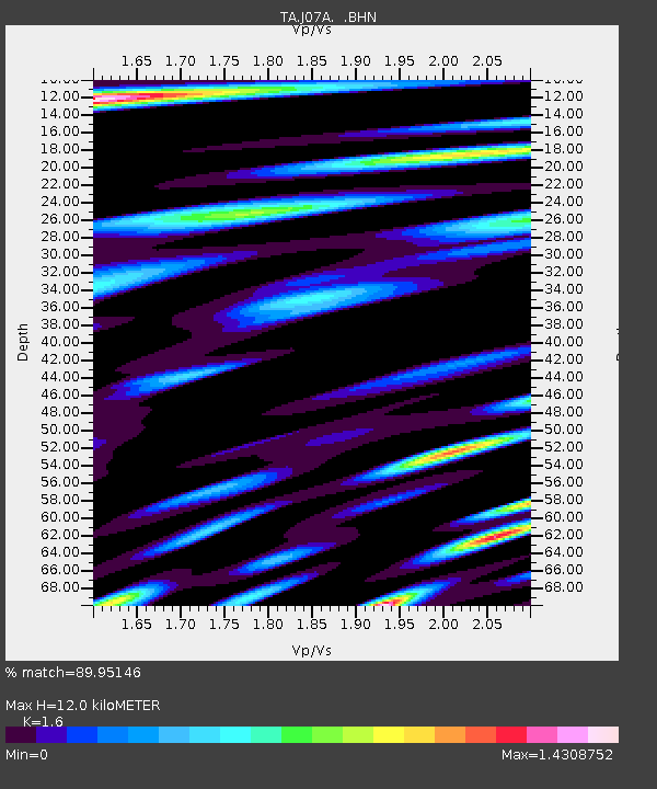
J07A Hines, OR, USA - Earthquake Result Viewer
| Earthquake location: |
Tonga Islands |
| Earthquake latitude/longitude: |
-15.2/-173.6 |
| Earthquake time(UTC): |
2006/07/07 (188) 07:26:12 GMT |
| Earthquake Depth: |
35 km |
| Earthquake Magnitude: |
5.7 MB, 5.9 MS, 6.0 MW, 6.0 MW |
| Earthquake Catalog/Contributor: |
WHDF/NEIC |
|
| Network: |
TA USArray Transportable Network (new EarthScope stations) |
| Station: |
J07A Hines, OR, USA |
| Lat/Lon: |
43.37 N/119.31 W |
| Elevation: |
1273 m |
|
| Distance: |
76.6 deg |
| Az: |
37.5 deg |
| Baz: |
233.691 deg |
| Ray Param: |
0.050841894 |
| Estimated Moho Depth: |
12.0 km |
| Estimated Crust Vp/Vs: |
1.60 |
| Assumed Crust Vp: |
6.279 km/s |
| Estimated Crust Vs: |
3.924 km/s |
| Estimated Crust Poisson's Ratio: |
0.18 |
|
| Radial Match: |
89.95146 % |
| Radial Bump: |
400 |
| Transverse Match: |
86.79934 % |
| Transverse Bump: |
400 |
| SOD ConfigId: |
2665 |
| Insert Time: |
2010-03-07 03:52:37.811 +0000 |
| GWidth: |
2.5 |
| Max Bumps: |
400 |
| Tol: |
0.001 |
|

Signal To Noise
| Channel | StoN | STA | LTA |
| TA:J07A: :BHN:20060707T07:37:28.42502Z | 2.4957619 | 1.4973521E-7 | 5.999579E-8 |
| TA:J07A: :BHE:20060707T07:37:28.42502Z | 2.0673895 | 1.8760814E-7 | 9.07464E-8 |
| TA:J07A: :BHZ:20060707T07:37:28.42502Z | 12.57484 | 7.393815E-7 | 5.879848E-8 |
| Arrivals |
| Ps | 1.2 SECOND |
| PpPs | 4.8 SECOND |
| PsPs/PpSs | 6.0 SECOND |


