You are here: Home > Network List > TS - TERRAscope (Southern California Seismic Network) Stations List
> Station MLAC Mammoth Lakes, California, USA > Earthquake Result Viewer
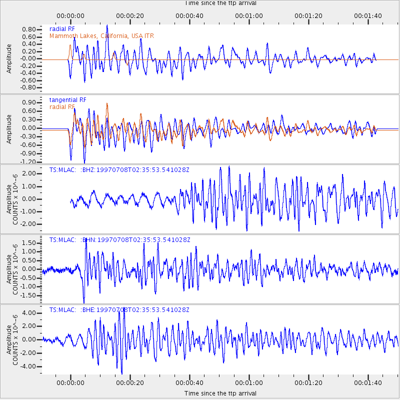
MLAC Mammoth Lakes, California, USA - Earthquake Result Viewer
*The percent match for this event was below the threshold and hence no stack was calculated.
| Earthquake location: |
Volcano Islands, Japan Region |
| Earthquake latitude/longitude: |
23.8/142.7 |
| Earthquake time(UTC): |
1997/07/08 (189) 02:24:07 GMT |
| Earthquake Depth: |
33 km |
| Earthquake Magnitude: |
5.8 MB, 5.6 MS, 5.9 UNKNOWN, 5.8 MW |
| Earthquake Catalog/Contributor: |
WHDF/NEIC |
|
| Network: |
TS TERRAscope (Southern California Seismic Network) |
| Station: |
MLAC Mammoth Lakes, California, USA |
| Lat/Lon: |
37.63 N/118.83 W |
| Elevation: |
2170 m |
|
| Distance: |
82.1 deg |
| Az: |
52.442 deg |
| Baz: |
293.854 deg |
| Ray Param: |
$rayparam |
*The percent match for this event was below the threshold and hence was not used in the summary stack. |
|
| Radial Match: |
67.72881 % |
| Radial Bump: |
400 |
| Transverse Match: |
68.08881 % |
| Transverse Bump: |
400 |
| SOD ConfigId: |
4480 |
| Insert Time: |
2010-02-26 14:27:33.671 +0000 |
| GWidth: |
2.5 |
| Max Bumps: |
400 |
| Tol: |
0.001 |
|
Signal To Noise
| Channel | StoN | STA | LTA |
| TS:MLAC: :BHN:19970708T02:35:53.541028Z | 4.786726 | 5.683358E-7 | 1.18731634E-7 |
| TS:MLAC: :BHE:19970708T02:35:53.541028Z | 2.2465672 | 6.5147896E-7 | 2.8998866E-7 |
| TS:MLAC: :BHZ:19970708T02:35:53.541028Z | 0.99779433 | 3.0893736E-7 | 3.0962028E-7 |
| Arrivals |
| Ps | |
| PpPs | |
| PsPs/PpSs | |


