You are here: Home > Network List > US - United States National Seismic Network Stations List
> Station HAWA Hanford, Washington, USA > Earthquake Result Viewer
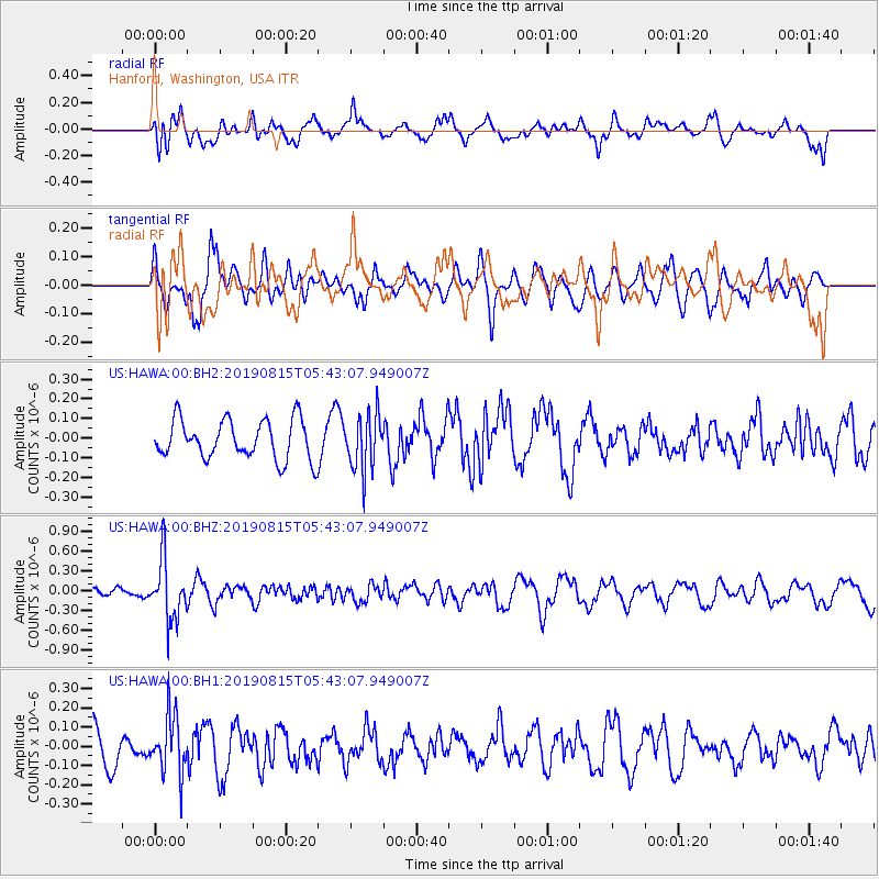
HAWA Hanford, Washington, USA - Earthquake Result Viewer
*The percent match for this event was below the threshold and hence no stack was calculated.
| Earthquake location: |
Near East Coast Of Honshu, Japan |
| Earthquake latitude/longitude: |
40.8/141.2 |
| Earthquake time(UTC): |
2019/08/15 (227) 05:32:53 GMT |
| Earthquake Depth: |
86 km |
| Earthquake Magnitude: |
5.4 Mww |
| Earthquake Catalog/Contributor: |
NEIC PDE/us |
|
| Network: |
US United States National Seismic Network |
| Station: |
HAWA Hanford, Washington, USA |
| Lat/Lon: |
46.39 N/119.53 W |
| Elevation: |
364 m |
|
| Distance: |
67.3 deg |
| Az: |
47.778 deg |
| Baz: |
305.716 deg |
| Ray Param: |
$rayparam |
*The percent match for this event was below the threshold and hence was not used in the summary stack. |
|
| Radial Match: |
49.67597 % |
| Radial Bump: |
400 |
| Transverse Match: |
65.18005 % |
| Transverse Bump: |
400 |
| SOD ConfigId: |
19053131 |
| Insert Time: |
2019-09-12 06:48:04.235 +0000 |
| GWidth: |
2.5 |
| Max Bumps: |
400 |
| Tol: |
0.001 |
|
Signal To Noise
| Channel | StoN | STA | LTA |
| US:HAWA:00:BHZ:20190815T05:43:07.949007Z | 4.7859654 | 4.6019707E-7 | 9.615554E-8 |
| US:HAWA:00:BH1:20190815T05:43:07.949007Z | 1.7204368 | 1.4948544E-7 | 8.688807E-8 |
| US:HAWA:00:BH2:20190815T05:43:07.949007Z | 1.4633089 | 1.4520266E-7 | 9.9228984E-8 |
| Arrivals |
| Ps | |
| PpPs | |
| PsPs/PpSs | |


