You are here: Home > Network List > TA - USArray Transportable Network (new EarthScope stations) Stations List
> Station O08A Rochester Mine, Lovelock, NV, USA > Earthquake Result Viewer
O08A Rochester Mine, Lovelock, NV, USA - Earthquake Result Viewer
| Earthquake location: |
Solomon Islands |
| Earthquake latitude/longitude: |
-10.9/162.1 |
| Earthquake time(UTC): |
2007/11/27 (331) 11:49:58 GMT |
| Earthquake Depth: |
16 km |
| Earthquake Magnitude: |
5.9 MB, 6.7 MS, 6.6 MW, 6.4 MW |
| Earthquake Catalog/Contributor: |
WHDF/NEIC |
|
| Network: |
TA USArray Transportable Network (new EarthScope stations) |
| Station: |
O08A Rochester Mine, Lovelock, NV, USA |
| Lat/Lon: |
40.29 N/118.15 W |
| Elevation: |
2138 m |
|
| Distance: |
89.3 deg |
| Az: |
48.82 deg |
| Baz: |
255.077 deg |
| Ray Param: |
0.041965045 |
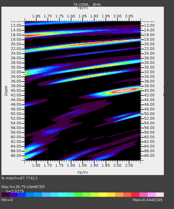
| Estimated Moho Depth: |
39.75 km |
| Estimated Crust Vp/Vs: |
2.03 |
| Assumed Crust Vp: |
6.276 km/s |
| Estimated Crust Vs: |
3.095 km/s |
| Estimated Crust Poisson's Ratio: |
0.34 |
|
| Radial Match: |
87.77413 % |
| Radial Bump: |
400 |
| Transverse Match: |
66.3824 % |
| Transverse Bump: |
400 |
| SOD ConfigId: |
2564 |
| Insert Time: |
2010-03-07 03:54:00.738 +0000 |
| GWidth: |
2.5 |
| Max Bumps: |
400 |
| Tol: |
0.001 |
|

Signal To Noise
| Channel | StoN | STA | LTA |
| TA:O08A: :BHN:20071127T12:02:21.650015Z | 2.1709232 | 5.3728365E-7 | 2.4749087E-7 |
| TA:O08A: :BHE:20071127T12:02:21.650015Z | 3.6433208 | 5.180486E-7 | 1.4219133E-7 |
| TA:O08A: :BHZ:20071127T12:02:21.650015Z | 6.829924 | 1.355172E-6 | 1.9841686E-7 |
| Arrivals |
| Ps | 6.6 SECOND |
| PpPs | 19 SECOND |
| PsPs/PpSs | 25 SECOND |


