You are here: Home > Network List > LD - Lamont-Doherty Cooperative Seismographic Network Stations List
> Station GEDE Greenville, DE, USA > Earthquake Result Viewer
GEDE Greenville, DE, USA - Earthquake Result Viewer
| Earthquake location: |
Off Coast Of Oregon |
| Earthquake latitude/longitude: |
43.6/-127.8 |
| Earthquake time(UTC): |
2019/08/29 (241) 15:08:00 GMT |
| Earthquake Depth: |
12 km |
| Earthquake Magnitude: |
6.4 Mi |
| Earthquake Catalog/Contributor: |
NEIC PDE/at |
|
| Network: |
LD Lamont-Doherty Cooperative Seismographic Network |
| Station: |
GEDE Greenville, DE, USA |
| Lat/Lon: |
39.81 N/75.64 W |
| Elevation: |
105 m |
|
| Distance: |
38.6 deg |
| Az: |
77.193 deg |
| Baz: |
293.13 deg |
| Ray Param: |
0.07548069 |
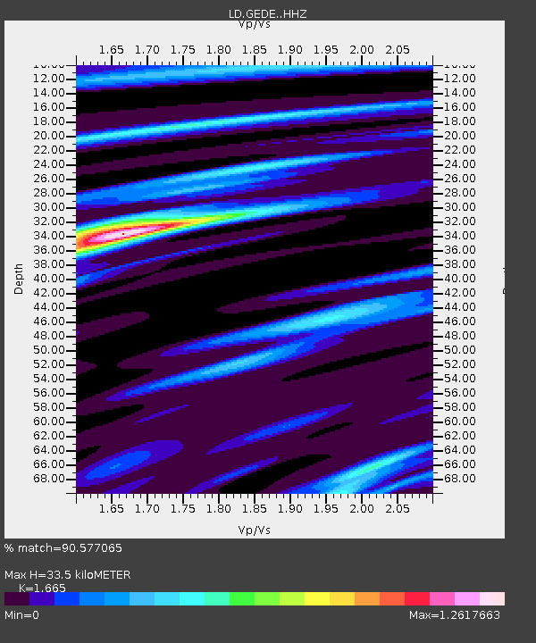
| Estimated Moho Depth: |
33.5 km |
| Estimated Crust Vp/Vs: |
1.66 |
| Assumed Crust Vp: |
6.287 km/s |
| Estimated Crust Vs: |
3.776 km/s |
| Estimated Crust Poisson's Ratio: |
0.22 |
|
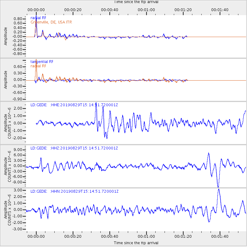
| Radial Match: |
90.577065 % |
| Radial Bump: |
238 |
| Transverse Match: |
68.58913 % |
| Transverse Bump: |
400 |
| SOD ConfigId: |
19053131 |
| Insert Time: |
2019-09-12 15:13:04.909 +0000 |
| GWidth: |
2.5 |
| Max Bumps: |
400 |
| Tol: |
0.001 |
|
Signal To Noise
| Channel | StoN | STA | LTA |
| LD:GEDE: :HHZ:20190829T15:14:51.720001Z | 5.276464 | 1.6825414E-6 | 3.1887672E-7 |
| LD:GEDE: :HHN:20190829T15:14:51.720001Z | 3.8077943 | 4.7598155E-7 | 1.250019E-7 |
| LD:GEDE: :HHE:20190829T15:14:51.720001Z | 5.0325565 | 9.2782295E-7 | 1.8436414E-7 |
| Arrivals |
| Ps | 3.8 SECOND |
| PpPs | 13 SECOND |
| PsPs/PpSs | 17 SECOND |


