You are here: Home > Network List > TA - USArray Transportable Network (new EarthScope stations) Stations List
> Station O08A Rochester Mine, Lovelock, NV, USA > Earthquake Result Viewer
O08A Rochester Mine, Lovelock, NV, USA - Earthquake Result Viewer

| Earthquake location: |
Solomon Islands |
| Earthquake latitude/longitude: |
-8.5/157.0 |
| Earthquake time(UTC): |
2007/04/01 (091) 20:39:56 GMT |
| Earthquake Depth: |
10 km |
| Earthquake Magnitude: |
6.8 MB, 7.9 MS, 8.1 MW, 7.7 ME |
| Earthquake Catalog/Contributor: |
WHDF/NEIC |
|
| Network: |
TA USArray Transportable Network (new EarthScope stations) |
| Station: |
O08A Rochester Mine, Lovelock, NV, USA |
| Lat/Lon: |
40.29 N/118.15 W |
| Elevation: |
2138 m |
|
| Distance: |
91.5 deg |
| Az: |
49.642 deg |
| Baz: |
260.236 deg |
| Ray Param: |
0.04160009 |
| Estimated Moho Depth: |
32.25 km |
| Estimated Crust Vp/Vs: |
1.60 |
| Assumed Crust Vp: |
6.276 km/s |
| Estimated Crust Vs: |
3.916 km/s |
| Estimated Crust Poisson's Ratio: |
0.18 |
|
| Radial Match: |
96.32911 % |
| Radial Bump: |
400 |
| Transverse Match: |
92.42255 % |
| Transverse Bump: |
400 |
| SOD ConfigId: |
2564 |
| Insert Time: |
2010-03-07 03:54:36.763 +0000 |
| GWidth: |
2.5 |
| Max Bumps: |
400 |
| Tol: |
0.001 |
|
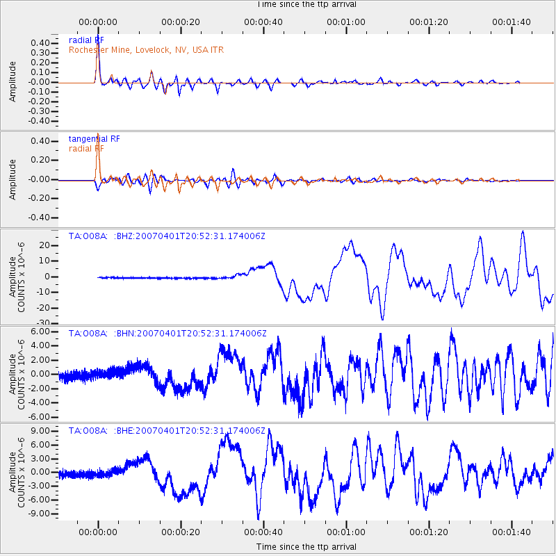
Signal To Noise
| Channel | StoN | STA | LTA |
| TA:O08A: :BHN:20070401T20:52:31.174006Z | 1.2734628 | 6.884727E-7 | 5.406304E-7 |
| TA:O08A: :BHE:20070401T20:52:31.174006Z | 1.197453 | 6.7593345E-7 | 5.6447595E-7 |
| TA:O08A: :BHZ:20070401T20:52:31.174006Z | 5.1069064 | 1.3279534E-6 | 2.600309E-7 |
| Arrivals |
| Ps | 3.2 SECOND |
| PpPs | 13 SECOND |
| PsPs/PpSs | 16 SECOND |


