You are here: Home > Network List > TA - USArray Transportable Network (new EarthScope stations) Stations List
> Station O08A Rochester Mine, Lovelock, NV, USA > Earthquake Result Viewer
O08A Rochester Mine, Lovelock, NV, USA - Earthquake Result Viewer
| Earthquake location: |
Vanuatu Islands |
| Earthquake latitude/longitude: |
-20.6/169.4 |
| Earthquake time(UTC): |
2007/03/25 (084) 00:40:01 GMT |
| Earthquake Depth: |
34 km |
| Earthquake Magnitude: |
6.5 MB, 7.0 MS, 7.1 MW, 7.1 MW |
| Earthquake Catalog/Contributor: |
WHDF/NEIC |
|
| Network: |
TA USArray Transportable Network (new EarthScope stations) |
| Station: |
O08A Rochester Mine, Lovelock, NV, USA |
| Lat/Lon: |
40.29 N/118.15 W |
| Elevation: |
2138 m |
|
| Distance: |
90.6 deg |
| Az: |
46.844 deg |
| Baz: |
243.299 deg |
| Ray Param: |
0.041660104 |
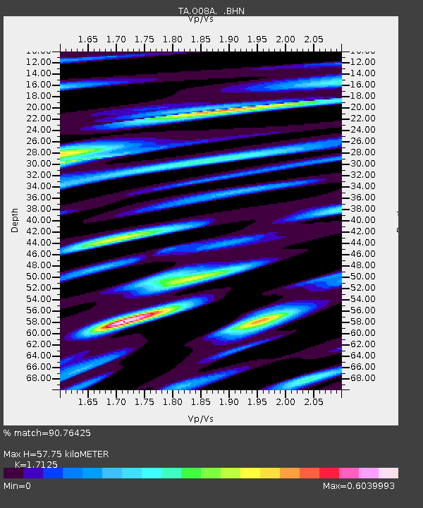
| Estimated Moho Depth: |
57.75 km |
| Estimated Crust Vp/Vs: |
1.71 |
| Assumed Crust Vp: |
6.276 km/s |
| Estimated Crust Vs: |
3.665 km/s |
| Estimated Crust Poisson's Ratio: |
0.24 |
|
| Radial Match: |
90.76425 % |
| Radial Bump: |
400 |
| Transverse Match: |
70.78635 % |
| Transverse Bump: |
400 |
| SOD ConfigId: |
2564 |
| Insert Time: |
2010-03-07 03:54:38.861 +0000 |
| GWidth: |
2.5 |
| Max Bumps: |
400 |
| Tol: |
0.001 |
|
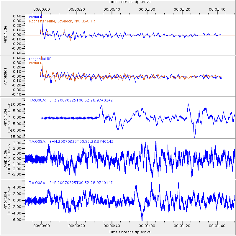
Signal To Noise
| Channel | StoN | STA | LTA |
| TA:O08A: :BHN:20070325T00:52:28.974014Z | 2.1686146 | 1.0536945E-6 | 4.8588373E-7 |
| TA:O08A: :BHE:20070325T00:52:28.974014Z | 2.1465964 | 1.4160283E-6 | 6.5966213E-7 |
| TA:O08A: :BHZ:20070325T00:52:28.974014Z | 17.738605 | 4.1199555E-6 | 2.3225927E-7 |
| Arrivals |
| Ps | 6.7 SECOND |
| PpPs | 24 SECOND |
| PsPs/PpSs | 31 SECOND |


