You are here: Home > Network List > TA - USArray Transportable Network (new EarthScope stations) Stations List
> Station O08A Rochester Mine, Lovelock, NV, USA > Earthquake Result Viewer
O08A Rochester Mine, Lovelock, NV, USA - Earthquake Result Viewer

| Earthquake location: |
Kermadec Islands, New Zealand |
| Earthquake latitude/longitude: |
-29.8/-178.0 |
| Earthquake time(UTC): |
2007/01/31 (031) 03:15:52 GMT |
| Earthquake Depth: |
34 km |
| Earthquake Magnitude: |
6.1 MB, 6.3 MS, 6.5 MW, 6.4 MW |
| Earthquake Catalog/Contributor: |
WHDF/NEIC |
|
| Network: |
TA USArray Transportable Network (new EarthScope stations) |
| Station: |
O08A Rochester Mine, Lovelock, NV, USA |
| Lat/Lon: |
40.29 N/118.15 W |
| Elevation: |
2138 m |
|
| Distance: |
89.1 deg |
| Az: |
41.414 deg |
| Baz: |
228.752 deg |
| Ray Param: |
0.04205674 |
| Estimated Moho Depth: |
28.25 km |
| Estimated Crust Vp/Vs: |
1.98 |
| Assumed Crust Vp: |
6.276 km/s |
| Estimated Crust Vs: |
3.17 km/s |
| Estimated Crust Poisson's Ratio: |
0.33 |
|
| Radial Match: |
82.54114 % |
| Radial Bump: |
400 |
| Transverse Match: |
75.90918 % |
| Transverse Bump: |
400 |
| SOD ConfigId: |
2564 |
| Insert Time: |
2010-03-07 03:54:42.051 +0000 |
| GWidth: |
2.5 |
| Max Bumps: |
400 |
| Tol: |
0.001 |
|
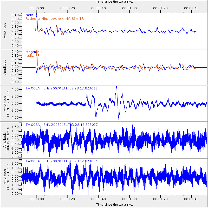
Signal To Noise
| Channel | StoN | STA | LTA |
| TA:O08A: :BHN:20070131T03:28:12.82302Z | 1.2292957 | 6.7293337E-7 | 5.474137E-7 |
| TA:O08A: :BHE:20070131T03:28:12.82302Z | 1.1479666 | 6.358308E-7 | 5.5387574E-7 |
| TA:O08A: :BHZ:20070131T03:28:12.82302Z | 3.440005 | 9.134664E-7 | 2.6554218E-7 |
| Arrivals |
| Ps | 4.5 SECOND |
| PpPs | 13 SECOND |
| PsPs/PpSs | 18 SECOND |


