You are here: Home > Network List > TA - USArray Transportable Network (new EarthScope stations) Stations List
> Station O08A Rochester Mine, Lovelock, NV, USA > Earthquake Result Viewer
O08A Rochester Mine, Lovelock, NV, USA - Earthquake Result Viewer
| Earthquake location: |
Kuril Islands |
| Earthquake latitude/longitude: |
46.6/153.3 |
| Earthquake time(UTC): |
2006/11/15 (319) 11:14:13 GMT |
| Earthquake Depth: |
10 km |
| Earthquake Magnitude: |
6.5 MB, 7.8 MS, 8.3 MW, 7.9 MW |
| Earthquake Catalog/Contributor: |
WHDF/NEIC |
|
| Network: |
TA USArray Transportable Network (new EarthScope stations) |
| Station: |
O08A Rochester Mine, Lovelock, NV, USA |
| Lat/Lon: |
40.29 N/118.15 W |
| Elevation: |
2138 m |
|
| Distance: |
61.3 deg |
| Az: |
60.623 deg |
| Baz: |
308.221 deg |
| Ray Param: |
0.060933042 |
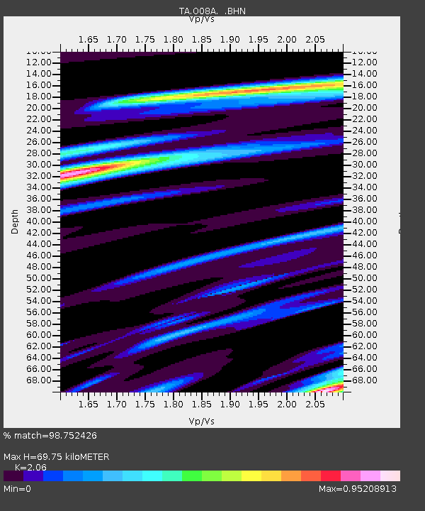
| Estimated Moho Depth: |
69.75 km |
| Estimated Crust Vp/Vs: |
2.06 |
| Assumed Crust Vp: |
6.276 km/s |
| Estimated Crust Vs: |
3.047 km/s |
| Estimated Crust Poisson's Ratio: |
0.35 |
|
| Radial Match: |
98.752426 % |
| Radial Bump: |
324 |
| Transverse Match: |
95.31554 % |
| Transverse Bump: |
400 |
| SOD ConfigId: |
2564 |
| Insert Time: |
2010-03-07 03:54:47.475 +0000 |
| GWidth: |
2.5 |
| Max Bumps: |
400 |
| Tol: |
0.001 |
|
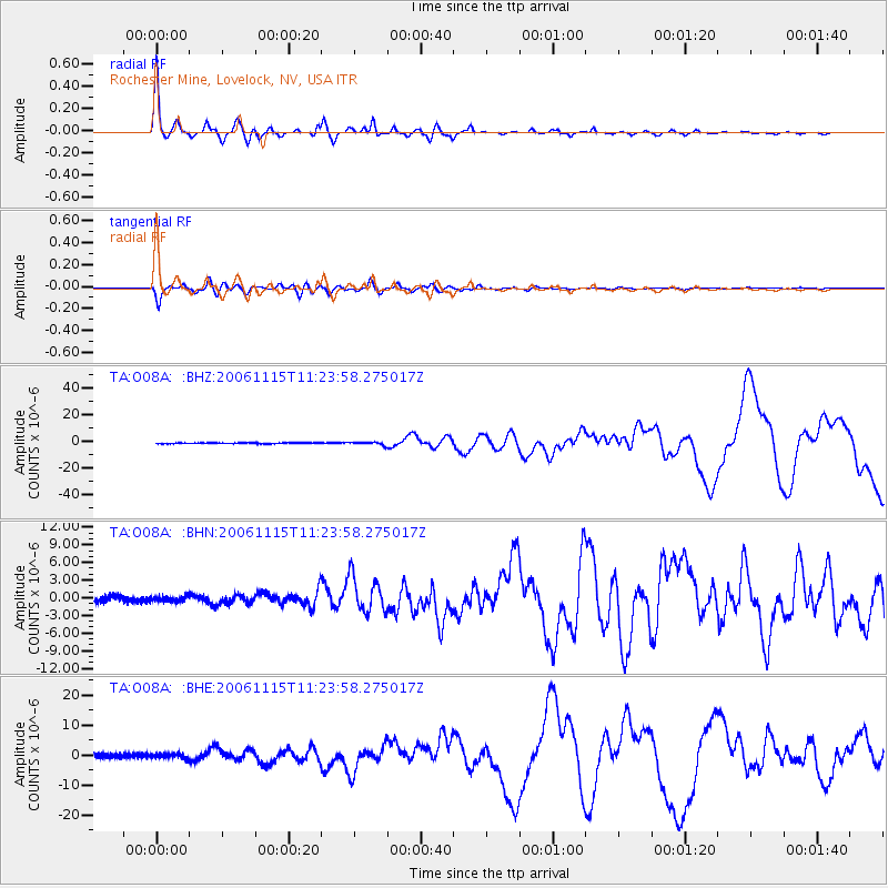
Signal To Noise
| Channel | StoN | STA | LTA |
| TA:O08A: :BHN:20061115T11:23:58.275017Z | 0.97136307 | 4.6588016E-7 | 4.7961487E-7 |
| TA:O08A: :BHE:20061115T11:23:58.275017Z | 1.2334654 | 7.9587414E-7 | 6.452343E-7 |
| TA:O08A: :BHZ:20061115T11:23:58.275017Z | 3.3862202 | 1.1442828E-6 | 3.3792332E-7 |
| Arrivals |
| Ps | 12 SECOND |
| PpPs | 33 SECOND |
| PsPs/PpSs | 45 SECOND |


