You are here: Home > Network List > TA - USArray Transportable Network (new EarthScope stations) Stations List
> Station O08A Rochester Mine, Lovelock, NV, USA > Earthquake Result Viewer
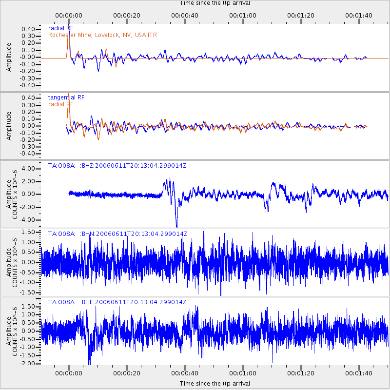
O08A Rochester Mine, Lovelock, NV, USA - Earthquake Result Viewer

| Earthquake location: |
Kyushu, Japan |
| Earthquake latitude/longitude: |
33.1/131.1 |
| Earthquake time(UTC): |
2006/06/11 (162) 20:01:26 GMT |
| Earthquake Depth: |
140 km |
| Earthquake Magnitude: |
5.9 MB, 6.3 MW, 6.3 MW |
| Earthquake Catalog/Contributor: |
WHDF/NEIC |
|
| Network: |
TA USArray Transportable Network (new EarthScope stations) |
| Station: |
O08A Rochester Mine, Lovelock, NV, USA |
| Lat/Lon: |
40.29 N/118.15 W |
| Elevation: |
2138 m |
|
| Distance: |
82.9 deg |
| Az: |
46.14 deg |
| Baz: |
307.723 deg |
| Ray Param: |
0.04623972 |
| Estimated Moho Depth: |
27.75 km |
| Estimated Crust Vp/Vs: |
1.69 |
| Assumed Crust Vp: |
6.276 km/s |
| Estimated Crust Vs: |
3.708 km/s |
| Estimated Crust Poisson's Ratio: |
0.23 |
|
| Radial Match: |
91.0723 % |
| Radial Bump: |
400 |
| Transverse Match: |
82.90375 % |
| Transverse Bump: |
400 |
| SOD ConfigId: |
5423 |
| Insert Time: |
2010-03-07 03:54:53.089 +0000 |
| GWidth: |
2.5 |
| Max Bumps: |
400 |
| Tol: |
0.001 |
|
Signal To Noise
| Channel | StoN | STA | LTA |
| TA:O08A: :BHN:20060611T20:13:04.299014Z | 0.8722871 | 4.2459598E-7 | 4.8676173E-7 |
| TA:O08A: :BHE:20060611T20:13:04.299014Z | 1.1465089 | 5.2170304E-7 | 4.5503617E-7 |
| TA:O08A: :BHZ:20060611T20:13:04.299014Z | 3.9218135 | 9.704137E-7 | 2.4744006E-7 |
| Arrivals |
| Ps | 3.1 SECOND |
| PpPs | 12 SECOND |
| PsPs/PpSs | 15 SECOND |


