You are here: Home > Network List > NE - New England Seismic Network Stations List
> Station HNH Hanover, NH, USA > Earthquake Result Viewer
HNH Hanover, NH, USA - Earthquake Result Viewer
| Earthquake location: |
Off Coast Of Oregon |
| Earthquake latitude/longitude: |
43.6/-127.8 |
| Earthquake time(UTC): |
2019/08/29 (241) 15:08:00 GMT |
| Earthquake Depth: |
12 km |
| Earthquake Magnitude: |
6.4 Mi |
| Earthquake Catalog/Contributor: |
NEIC PDE/at |
|
| Network: |
NE New England Seismic Network |
| Station: |
HNH Hanover, NH, USA |
| Lat/Lon: |
43.71 N/72.29 W |
| Elevation: |
180 m |
|
| Distance: |
39.5 deg |
| Az: |
69.986 deg |
| Baz: |
289.752 deg |
| Ray Param: |
0.07495363 |
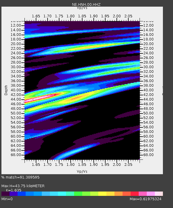
| Estimated Moho Depth: |
43.75 km |
| Estimated Crust Vp/Vs: |
1.63 |
| Assumed Crust Vp: |
6.419 km/s |
| Estimated Crust Vs: |
3.926 km/s |
| Estimated Crust Poisson's Ratio: |
0.20 |
|
| Radial Match: |
91.389595 % |
| Radial Bump: |
400 |
| Transverse Match: |
89.90104 % |
| Transverse Bump: |
400 |
| SOD ConfigId: |
19053131 |
| Insert Time: |
2019-09-12 15:14:15.347 +0000 |
| GWidth: |
2.5 |
| Max Bumps: |
400 |
| Tol: |
0.001 |
|

Signal To Noise
| Channel | StoN | STA | LTA |
| NE:HNH:00:HHZ:20190829T15:14:59.343994Z | 8.633054 | 2.525379E-6 | 2.9252442E-7 |
| NE:HNH:00:HH1:20190829T15:14:59.343994Z | 1.6244786 | 2.7763681E-7 | 1.7090827E-7 |
| NE:HNH:00:HH2:20190829T15:14:59.343994Z | 7.766186 | 1.6150913E-6 | 2.0796453E-7 |
| Arrivals |
| Ps | 4.7 SECOND |
| PpPs | 17 SECOND |
| PsPs/PpSs | 21 SECOND |


