You are here: Home > Network List > NM - Cooperative New Madrid Seismic Network Stations List
> Station CLTN Cedars of Lebanon,TN > Earthquake Result Viewer
CLTN Cedars of Lebanon,TN - Earthquake Result Viewer
| Earthquake location: |
Off Coast Of Oregon |
| Earthquake latitude/longitude: |
43.6/-127.8 |
| Earthquake time(UTC): |
2019/08/29 (241) 15:08:00 GMT |
| Earthquake Depth: |
12 km |
| Earthquake Magnitude: |
6.4 Mi |
| Earthquake Catalog/Contributor: |
NEIC PDE/at |
|
| Network: |
NM Cooperative New Madrid Seismic Network |
| Station: |
CLTN Cedars of Lebanon,TN |
| Lat/Lon: |
36.09 N/86.33 W |
| Elevation: |
208 m |
|
| Distance: |
32.4 deg |
| Az: |
89.077 deg |
| Baz: |
296.266 deg |
| Ray Param: |
0.0786606 |
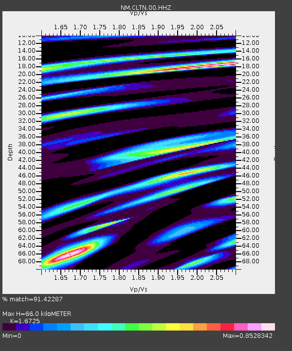
| Estimated Moho Depth: |
66.0 km |
| Estimated Crust Vp/Vs: |
1.67 |
| Assumed Crust Vp: |
6.444 km/s |
| Estimated Crust Vs: |
3.853 km/s |
| Estimated Crust Poisson's Ratio: |
0.22 |
|
| Radial Match: |
91.42287 % |
| Radial Bump: |
359 |
| Transverse Match: |
69.70877 % |
| Transverse Bump: |
400 |
| SOD ConfigId: |
19053131 |
| Insert Time: |
2019-09-12 15:14:18.471 +0000 |
| GWidth: |
2.5 |
| Max Bumps: |
400 |
| Tol: |
0.001 |
|

Signal To Noise
| Channel | StoN | STA | LTA |
| NM:CLTN:00:HHZ:20190829T15:13:58.904999Z | 17.815685 | 8.655991E-7 | 4.8586347E-8 |
| NM:CLTN:00:HHN:20190829T15:13:58.904999Z | 6.7155676 | 2.8870164E-7 | 4.298991E-8 |
| NM:CLTN:00:HHE:20190829T15:13:58.904999Z | 8.984763 | 5.441421E-7 | 6.056277E-8 |
| Arrivals |
| Ps | 7.5 SECOND |
| PpPs | 25 SECOND |
| PsPs/PpSs | 33 SECOND |


