You are here: Home > Network List > TA - USArray Transportable Network (new EarthScope stations) Stations List
> Station A21K Barrow, AK, USA > Earthquake Result Viewer
A21K Barrow, AK, USA - Earthquake Result Viewer

| Earthquake location: |
Off Coast Of Oregon |
| Earthquake latitude/longitude: |
43.6/-127.8 |
| Earthquake time(UTC): |
2019/08/29 (241) 15:08:00 GMT |
| Earthquake Depth: |
12 km |
| Earthquake Magnitude: |
6.4 Mi |
| Earthquake Catalog/Contributor: |
NEIC PDE/at |
|
| Network: |
TA USArray Transportable Network (new EarthScope stations) |
| Station: |
A21K Barrow, AK, USA |
| Lat/Lon: |
71.32 N/156.62 W |
| Elevation: |
577 m |
|
| Distance: |
31.2 deg |
| Az: |
342.517 deg |
| Baz: |
137.362 deg |
| Ray Param: |
0.07913539 |
| Estimated Moho Depth: |
27.5 km |
| Estimated Crust Vp/Vs: |
1.80 |
| Assumed Crust Vp: |
6.048 km/s |
| Estimated Crust Vs: |
3.369 km/s |
| Estimated Crust Poisson's Ratio: |
0.27 |
|
| Radial Match: |
95.018906 % |
| Radial Bump: |
303 |
| Transverse Match: |
76.6627 % |
| Transverse Bump: |
372 |
| SOD ConfigId: |
19053131 |
| Insert Time: |
2019-09-12 15:15:22.925 +0000 |
| GWidth: |
2.5 |
| Max Bumps: |
400 |
| Tol: |
0.001 |
|
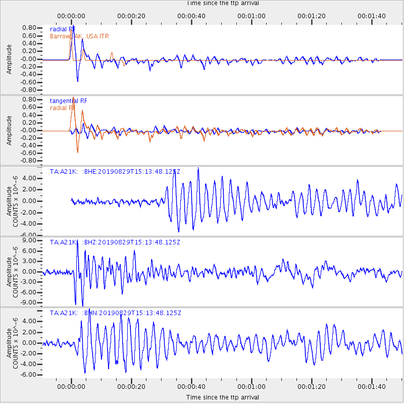
Signal To Noise
| Channel | StoN | STA | LTA |
| TA:A21K: :BHZ:20190829T15:13:48.125Z | 12.961538 | 4.681075E-6 | 3.611512E-7 |
| TA:A21K: :BHN:20190829T15:13:48.125Z | 7.9647284 | 2.2245456E-6 | 2.792996E-7 |
| TA:A21K: :BHE:20190829T15:13:48.125Z | 9.330098 | 2.504062E-6 | 2.6838538E-7 |
| Arrivals |
| Ps | 3.9 SECOND |
| PpPs | 12 SECOND |
| PsPs/PpSs | 16 SECOND |


