You are here: Home > Network List > TA - USArray Transportable Network (new EarthScope stations) Stations List
> Station B18K Kokolik River, AK, USA > Earthquake Result Viewer
B18K Kokolik River, AK, USA - Earthquake Result Viewer
| Earthquake location: |
Off Coast Of Oregon |
| Earthquake latitude/longitude: |
43.6/-127.8 |
| Earthquake time(UTC): |
2019/08/29 (241) 15:08:00 GMT |
| Earthquake Depth: |
12 km |
| Earthquake Magnitude: |
6.4 Mi |
| Earthquake Catalog/Contributor: |
NEIC PDE/at |
|
| Network: |
TA USArray Transportable Network (new EarthScope stations) |
| Station: |
B18K Kokolik River, AK, USA |
| Lat/Lon: |
69.36 N/161.80 W |
| Elevation: |
222 m |
|
| Distance: |
31.1 deg |
| Az: |
337.424 deg |
| Baz: |
128.123 deg |
| Ray Param: |
0.079147615 |
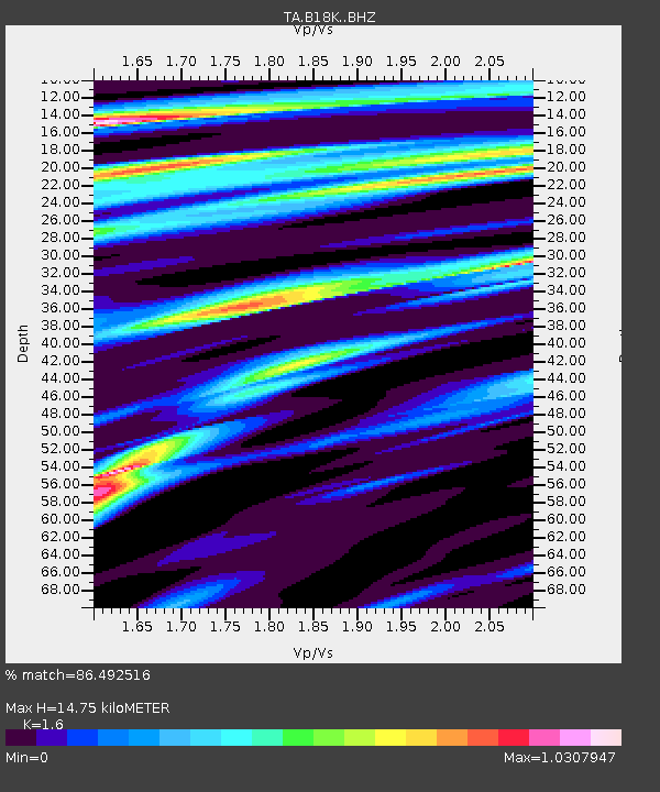
| Estimated Moho Depth: |
14.75 km |
| Estimated Crust Vp/Vs: |
1.60 |
| Assumed Crust Vp: |
5.906 km/s |
| Estimated Crust Vs: |
3.692 km/s |
| Estimated Crust Poisson's Ratio: |
0.18 |
|
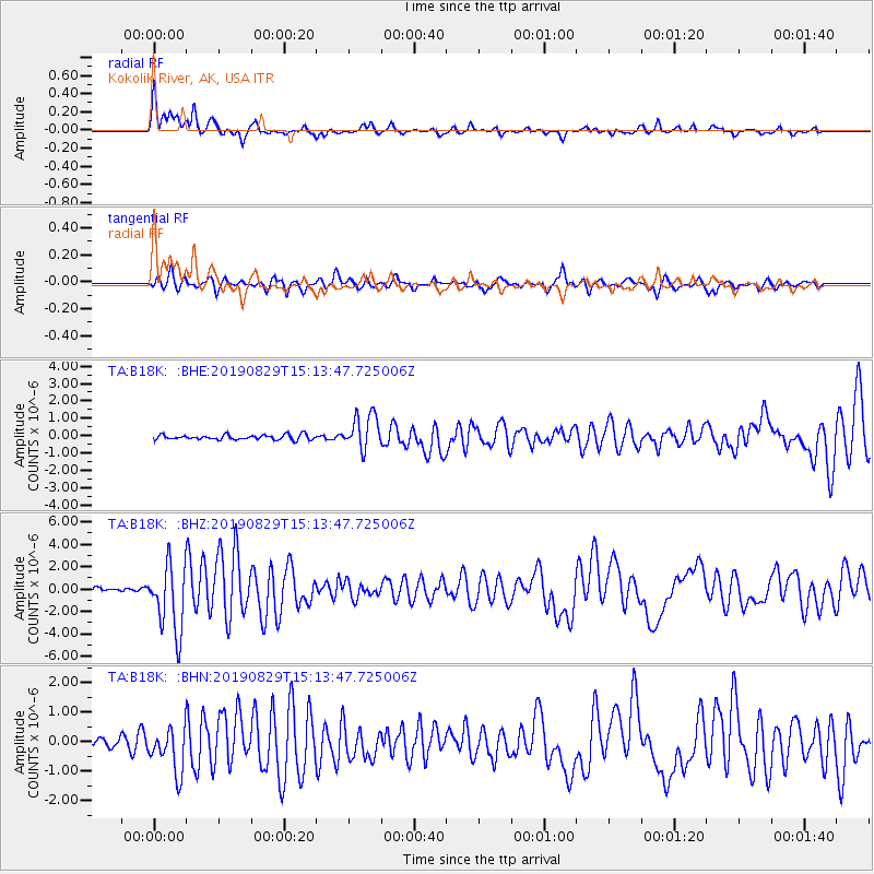
| Radial Match: |
86.492516 % |
| Radial Bump: |
367 |
| Transverse Match: |
78.812515 % |
| Transverse Bump: |
400 |
| SOD ConfigId: |
19053131 |
| Insert Time: |
2019-09-12 15:15:24.966 +0000 |
| GWidth: |
2.5 |
| Max Bumps: |
400 |
| Tol: |
0.001 |
|
Signal To Noise
| Channel | StoN | STA | LTA |
| TA:B18K: :BHZ:20190829T15:13:47.725006Z | 13.350484 | 3.0650276E-6 | 2.2958177E-7 |
| TA:B18K: :BHN:20190829T15:13:47.725006Z | 4.063145 | 7.469387E-7 | 1.8383265E-7 |
| TA:B18K: :BHE:20190829T15:13:47.725006Z | 7.1559663 | 1.0057993E-6 | 1.4055395E-7 |
| Arrivals |
| Ps | 1.6 SECOND |
| PpPs | 6.0 SECOND |
| PsPs/PpSs | 7.6 SECOND |


