You are here: Home > Network List > CN - Canadian National Seismograph Network Stations List
> Station INK INUVIK, NT > Earthquake Result Viewer
INK INUVIK, NT - Earthquake Result Viewer
*The percent match for this event was below the threshold and hence no stack was calculated.
| Earthquake location: |
Myanmar |
| Earthquake latitude/longitude: |
22.7/95.5 |
| Earthquake time(UTC): |
2019/08/31 (243) 15:09:22 GMT |
| Earthquake Depth: |
10 km |
| Earthquake Magnitude: |
5.5 Mww |
| Earthquake Catalog/Contributor: |
NEIC PDE/us |
|
| Network: |
CN Canadian National Seismograph Network |
| Station: |
INK INUVIK, NT |
| Lat/Lon: |
68.31 N/133.53 W |
| Elevation: |
44 m |
|
| Distance: |
82.4 deg |
| Az: |
16.457 deg |
| Baz: |
315.3 deg |
| Ray Param: |
$rayparam |
*The percent match for this event was below the threshold and hence was not used in the summary stack. |
|
| Radial Match: |
40.331955 % |
| Radial Bump: |
400 |
| Transverse Match: |
36.878292 % |
| Transverse Bump: |
400 |
| SOD ConfigId: |
19053131 |
| Insert Time: |
2019-09-14 15:14:08.008 +0000 |
| GWidth: |
2.5 |
| Max Bumps: |
400 |
| Tol: |
0.001 |
|
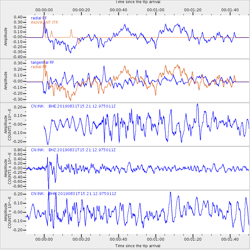
Signal To Noise
| Channel | StoN | STA | LTA |
| CN:INK: :BHZ:20190831T15:21:12.975011Z | 6.0371575 | 2.858418E-7 | 4.7347083E-8 |
| CN:INK: :BHN:20190831T15:21:12.975011Z | 1.3425897 | 1.0686927E-7 | 7.959935E-8 |
| CN:INK: :BHE:20190831T15:21:12.975011Z | 0.9592738 | 7.1230765E-8 | 7.4254885E-8 |
| Arrivals |
| Ps | |
| PpPs | |
| PsPs/PpSs | |


