You are here: Home > Network List > TA - USArray Transportable Network (new EarthScope stations) Stations List
> Station O10A Cortez Mining, Crescent City, NV, USA > Earthquake Result Viewer
O10A Cortez Mining, Crescent City, NV, USA - Earthquake Result Viewer

| Earthquake location: |
East Of Kuril Islands |
| Earthquake latitude/longitude: |
46.0/154.2 |
| Earthquake time(UTC): |
2007/10/25 (298) 13:50:02 GMT |
| Earthquake Depth: |
10 km |
| Earthquake Magnitude: |
6.0 MB, 5.7 MS, 6.1 MW, 5.9 MW |
| Earthquake Catalog/Contributor: |
WHDF/NEIC |
|
| Network: |
TA USArray Transportable Network (new EarthScope stations) |
| Station: |
O10A Cortez Mining, Crescent City, NV, USA |
| Lat/Lon: |
40.29 N/116.50 W |
| Elevation: |
1470 m |
|
| Distance: |
62.0 deg |
| Az: |
59.978 deg |
| Baz: |
307.916 deg |
| Ray Param: |
0.060483504 |
| Estimated Moho Depth: |
54.5 km |
| Estimated Crust Vp/Vs: |
1.77 |
| Assumed Crust Vp: |
6.276 km/s |
| Estimated Crust Vs: |
3.551 km/s |
| Estimated Crust Poisson's Ratio: |
0.26 |
|
| Radial Match: |
88.39925 % |
| Radial Bump: |
400 |
| Transverse Match: |
80.4613 % |
| Transverse Bump: |
400 |
| SOD ConfigId: |
2564 |
| Insert Time: |
2010-03-07 03:56:37.484 +0000 |
| GWidth: |
2.5 |
| Max Bumps: |
400 |
| Tol: |
0.001 |
|
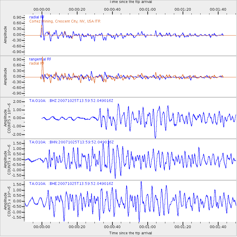
Signal To Noise
| Channel | StoN | STA | LTA |
| TA:O10A: :BHN:20071025T13:59:52.049016Z | 3.3800194 | 3.4603235E-7 | 1.0237585E-7 |
| TA:O10A: :BHE:20071025T13:59:52.049016Z | 2.3933325 | 4.4670483E-7 | 1.8664555E-7 |
| TA:O10A: :BHZ:20071025T13:59:52.049016Z | 4.0339274 | 4.7266846E-7 | 1.17173265E-7 |
| Arrivals |
| Ps | 7.0 SECOND |
| PpPs | 23 SECOND |
| PsPs/PpSs | 30 SECOND |


