You are here: Home > Network List > TA - USArray Transportable Network (new EarthScope stations) Stations List
> Station O10A Cortez Mining, Crescent City, NV, USA > Earthquake Result Viewer
O10A Cortez Mining, Crescent City, NV, USA - Earthquake Result Viewer

| Earthquake location: |
Kuril Islands |
| Earthquake latitude/longitude: |
45.8/150.1 |
| Earthquake time(UTC): |
2007/09/03 (246) 16:14:53 GMT |
| Earthquake Depth: |
94 km |
| Earthquake Magnitude: |
6.3 MB, 6.2 MW, 6.2 ME |
| Earthquake Catalog/Contributor: |
WHDF/NEIC |
|
| Network: |
TA USArray Transportable Network (new EarthScope stations) |
| Station: |
O10A Cortez Mining, Crescent City, NV, USA |
| Lat/Lon: |
40.29 N/116.50 W |
| Elevation: |
1470 m |
|
| Distance: |
64.6 deg |
| Az: |
57.674 deg |
| Baz: |
309.434 deg |
| Ray Param: |
0.058554705 |
| Estimated Moho Depth: |
34.75 km |
| Estimated Crust Vp/Vs: |
2.02 |
| Assumed Crust Vp: |
6.276 km/s |
| Estimated Crust Vs: |
3.107 km/s |
| Estimated Crust Poisson's Ratio: |
0.34 |
|
| Radial Match: |
88.49145 % |
| Radial Bump: |
400 |
| Transverse Match: |
78.402565 % |
| Transverse Bump: |
400 |
| SOD ConfigId: |
2564 |
| Insert Time: |
2010-03-07 03:56:43.583 +0000 |
| GWidth: |
2.5 |
| Max Bumps: |
400 |
| Tol: |
0.001 |
|
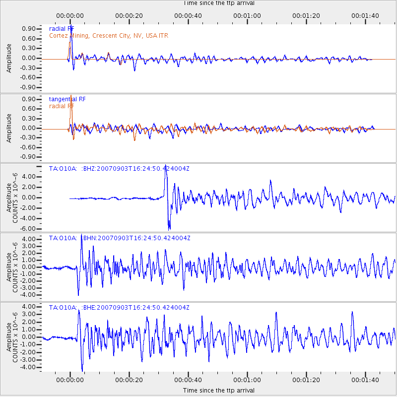
Signal To Noise
| Channel | StoN | STA | LTA |
| TA:O10A: :BHN:20070903T16:24:50.424004Z | 15.614516 | 1.582078E-6 | 1.01320964E-7 |
| TA:O10A: :BHE:20070903T16:24:50.424004Z | 12.362385 | 1.718384E-6 | 1.3900102E-7 |
| TA:O10A: :BHZ:20070903T16:24:50.424004Z | 32.247574 | 3.0021913E-6 | 9.309821E-8 |
| Arrivals |
| Ps | 5.8 SECOND |
| PpPs | 16 SECOND |
| PsPs/PpSs | 22 SECOND |


