You are here: Home > Network List > TA - USArray Transportable Network (new EarthScope stations) Stations List
> Station O10A Cortez Mining, Crescent City, NV, USA > Earthquake Result Viewer
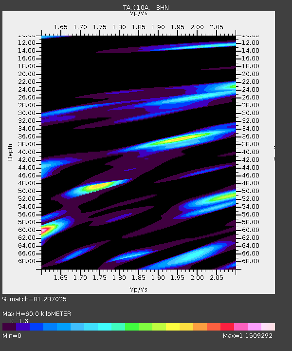
O10A Cortez Mining, Crescent City, NV, USA - Earthquake Result Viewer
| Earthquake location: |
Ryukyu Islands, Japan |
| Earthquake latitude/longitude: |
27.5/128.4 |
| Earthquake time(UTC): |
2007/04/20 (110) 19:37:58 GMT |
| Earthquake Depth: |
42 km |
| Earthquake Magnitude: |
5.9 MB, 5.1 MS, 5.7 MW, 5.7 MW |
| Earthquake Catalog/Contributor: |
WHDF/NEIC |
|
| Network: |
TA USArray Transportable Network (new EarthScope stations) |
| Station: |
O10A Cortez Mining, Crescent City, NV, USA |
| Lat/Lon: |
40.29 N/116.50 W |
| Elevation: |
1470 m |
|
| Distance: |
89.6 deg |
| Az: |
43.834 deg |
| Baz: |
306.439 deg |
| Ray Param: |
0.041727394 |
| Estimated Moho Depth: |
60.0 km |
| Estimated Crust Vp/Vs: |
1.60 |
| Assumed Crust Vp: |
6.276 km/s |
| Estimated Crust Vs: |
3.922 km/s |
| Estimated Crust Poisson's Ratio: |
0.18 |
|
| Radial Match: |
81.287025 % |
| Radial Bump: |
400 |
| Transverse Match: |
78.8136 % |
| Transverse Bump: |
400 |
| SOD ConfigId: |
2564 |
| Insert Time: |
2010-03-07 03:57:07.399 +0000 |
| GWidth: |
2.5 |
| Max Bumps: |
400 |
| Tol: |
0.001 |
|

Signal To Noise
| Channel | StoN | STA | LTA |
| TA:O10A: :BHN:20070420T19:50:20.12502Z | 2.5188363 | 2.9070645E-7 | 1.15413E-7 |
| TA:O10A: :BHE:20070420T19:50:20.12502Z | 5.3274307 | 5.206696E-7 | 9.7733704E-8 |
| TA:O10A: :BHZ:20070420T19:50:20.12502Z | 4.615461 | 7.6164673E-7 | 1.6502074E-7 |
| Arrivals |
| Ps | 5.9 SECOND |
| PpPs | 24 SECOND |
| PsPs/PpSs | 30 SECOND |


