You are here: Home > Network List > TA - USArray Transportable Network (new EarthScope stations) Stations List
> Station O10A Cortez Mining, Crescent City, NV, USA > Earthquake Result Viewer
O10A Cortez Mining, Crescent City, NV, USA - Earthquake Result Viewer

| Earthquake location: |
Primor'ye, Russia |
| Earthquake latitude/longitude: |
43.2/133.5 |
| Earthquake time(UTC): |
2007/03/09 (068) 03:22:42 GMT |
| Earthquake Depth: |
441 km |
| Earthquake Magnitude: |
6.1 MB, 6.0 MW, 6.0 MW |
| Earthquake Catalog/Contributor: |
WHDF/NEIC |
|
| Network: |
TA USArray Transportable Network (new EarthScope stations) |
| Station: |
O10A Cortez Mining, Crescent City, NV, USA |
| Lat/Lon: |
40.29 N/116.50 W |
| Elevation: |
1470 m |
|
| Distance: |
75.6 deg |
| Az: |
47.918 deg |
| Baz: |
314.825 deg |
| Ray Param: |
0.050235778 |
| Estimated Moho Depth: |
45.0 km |
| Estimated Crust Vp/Vs: |
1.81 |
| Assumed Crust Vp: |
6.276 km/s |
| Estimated Crust Vs: |
3.477 km/s |
| Estimated Crust Poisson's Ratio: |
0.28 |
|
| Radial Match: |
83.00083 % |
| Radial Bump: |
400 |
| Transverse Match: |
67.80151 % |
| Transverse Bump: |
400 |
| SOD ConfigId: |
2564 |
| Insert Time: |
2010-03-07 03:57:11.521 +0000 |
| GWidth: |
2.5 |
| Max Bumps: |
400 |
| Tol: |
0.001 |
|
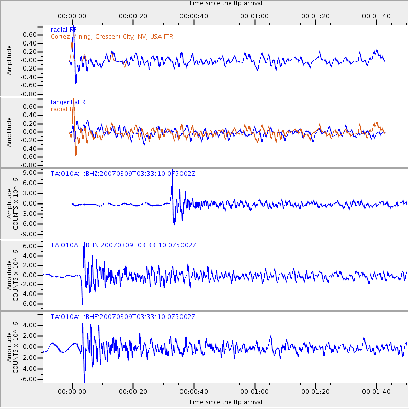
Signal To Noise
| Channel | StoN | STA | LTA |
| TA:O10A: :BHN:20070309T03:33:10.075002Z | 5.133387 | 2.2249715E-6 | 4.3343147E-7 |
| TA:O10A: :BHE:20070309T03:33:10.075002Z | 3.3704653 | 1.8625256E-6 | 5.526019E-7 |
| TA:O10A: :BHZ:20070309T03:33:10.075002Z | 12.744988 | 2.8098707E-6 | 2.2046866E-7 |
| Arrivals |
| Ps | 5.9 SECOND |
| PpPs | 20 SECOND |
| PsPs/PpSs | 25 SECOND |


