You are here: Home > Network List > TA - USArray Transportable Network (new EarthScope stations) Stations List
> Station O10A Cortez Mining, Crescent City, NV, USA > Earthquake Result Viewer
O10A Cortez Mining, Crescent City, NV, USA - Earthquake Result Viewer

| Earthquake location: |
Near S. Coast Of Honshu, Japan |
| Earthquake latitude/longitude: |
34.9/138.6 |
| Earthquake time(UTC): |
2007/01/15 (015) 18:17:59 GMT |
| Earthquake Depth: |
170 km |
| Earthquake Magnitude: |
5.7 MB, 5.9 MW, 5.9 MW |
| Earthquake Catalog/Contributor: |
WHDF/NEIC |
|
| Network: |
TA USArray Transportable Network (new EarthScope stations) |
| Station: |
O10A Cortez Mining, Crescent City, NV, USA |
| Lat/Lon: |
40.29 N/116.50 W |
| Elevation: |
1470 m |
|
| Distance: |
78.1 deg |
| Az: |
49.065 deg |
| Baz: |
305.721 deg |
| Ray Param: |
0.049423568 |
| Estimated Moho Depth: |
24.25 km |
| Estimated Crust Vp/Vs: |
1.80 |
| Assumed Crust Vp: |
6.276 km/s |
| Estimated Crust Vs: |
3.482 km/s |
| Estimated Crust Poisson's Ratio: |
0.28 |
|
| Radial Match: |
81.02174 % |
| Radial Bump: |
400 |
| Transverse Match: |
61.580338 % |
| Transverse Bump: |
400 |
| SOD ConfigId: |
2564 |
| Insert Time: |
2010-03-07 03:57:15.804 +0000 |
| GWidth: |
2.5 |
| Max Bumps: |
400 |
| Tol: |
0.001 |
|
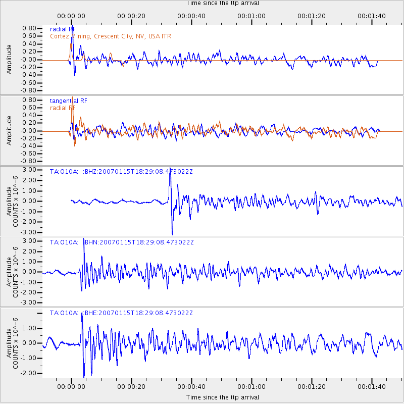
Signal To Noise
| Channel | StoN | STA | LTA |
| TA:O10A: :BHN:20070115T18:29:08.473022Z | 5.4743705 | 9.555932E-7 | 1.7455766E-7 |
| TA:O10A: :BHE:20070115T18:29:08.473022Z | 4.566115 | 8.122678E-7 | 1.7789034E-7 |
| TA:O10A: :BHZ:20070115T18:29:08.473022Z | 11.259486 | 1.2338583E-6 | 1.0958388E-7 |
| Arrivals |
| Ps | 3.2 SECOND |
| PpPs | 11 SECOND |
| PsPs/PpSs | 14 SECOND |


