You are here: Home > Network List > TA - USArray Transportable Network (new EarthScope stations) Stations List
> Station O10A Cortez Mining, Crescent City, NV, USA > Earthquake Result Viewer
O10A Cortez Mining, Crescent City, NV, USA - Earthquake Result Viewer

| Earthquake location: |
Near Coast Of Guatemala |
| Earthquake latitude/longitude: |
14.0/-91.2 |
| Earthquake time(UTC): |
2006/12/03 (337) 20:52:15 GMT |
| Earthquake Depth: |
61 km |
| Earthquake Magnitude: |
5.8 MB, 5.9 MW, 5.9 MW |
| Earthquake Catalog/Contributor: |
WHDF/NEIC |
|
| Network: |
TA USArray Transportable Network (new EarthScope stations) |
| Station: |
O10A Cortez Mining, Crescent City, NV, USA |
| Lat/Lon: |
40.29 N/116.50 W |
| Elevation: |
1470 m |
|
| Distance: |
34.3 deg |
| Az: |
324.555 deg |
| Baz: |
132.613 deg |
| Ray Param: |
0.07764875 |
| Estimated Moho Depth: |
22.75 km |
| Estimated Crust Vp/Vs: |
1.60 |
| Assumed Crust Vp: |
6.276 km/s |
| Estimated Crust Vs: |
3.922 km/s |
| Estimated Crust Poisson's Ratio: |
0.18 |
|
| Radial Match: |
81.34421 % |
| Radial Bump: |
400 |
| Transverse Match: |
83.77025 % |
| Transverse Bump: |
400 |
| SOD ConfigId: |
2564 |
| Insert Time: |
2010-03-07 03:57:21.200 +0000 |
| GWidth: |
2.5 |
| Max Bumps: |
400 |
| Tol: |
0.001 |
|
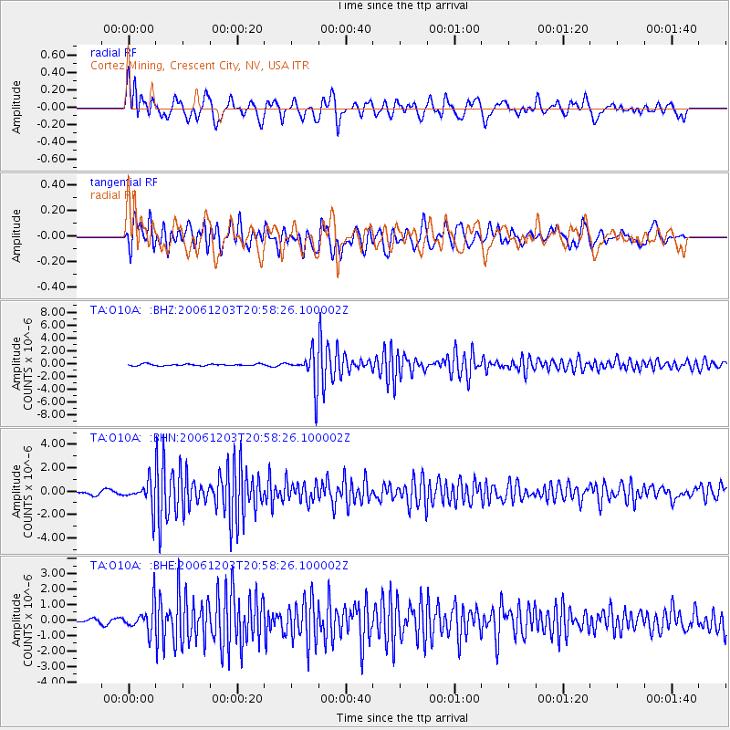
Signal To Noise
| Channel | StoN | STA | LTA |
| TA:O10A: :BHN:20061203T20:58:26.100002Z | 6.1730065 | 1.0891835E-6 | 1.7644295E-7 |
| TA:O10A: :BHE:20061203T20:58:26.100002Z | 3.9745035 | 8.6587227E-7 | 2.1785671E-7 |
| TA:O10A: :BHZ:20061203T20:58:26.100002Z | 20.736609 | 2.6602568E-6 | 1.2828794E-7 |
| Arrivals |
| Ps | 2.4 SECOND |
| PpPs | 8.7 SECOND |
| PsPs/PpSs | 11 SECOND |


