You are here: Home > Network List > WY - Yellowstone Wyoming Seismic Network Stations List
> Station YHR Hawk's Rest, WY, USA > Earthquake Result Viewer
YHR Hawk's Rest, WY, USA - Earthquake Result Viewer
| Earthquake location: |
Southern East Pacific Rise |
| Earthquake latitude/longitude: |
-50.0/-114.5 |
| Earthquake time(UTC): |
2019/08/31 (243) 23:54:40 GMT |
| Earthquake Depth: |
10 km |
| Earthquake Magnitude: |
5.7 Mww |
| Earthquake Catalog/Contributor: |
NEIC PDE/us |
|
| Network: |
WY Yellowstone Wyoming Seismic Network |
| Station: |
YHR Hawk's Rest, WY, USA |
| Lat/Lon: |
44.11 N/110.08 W |
| Elevation: |
2976 m |
|
| Distance: |
93.8 deg |
| Az: |
3.165 deg |
| Baz: |
182.834 deg |
| Ray Param: |
0.041188005 |
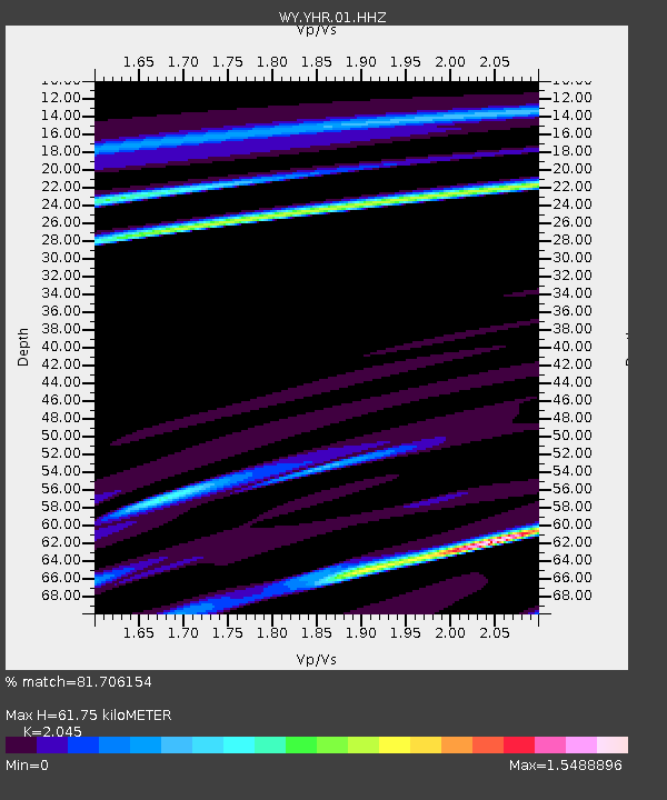
| Estimated Moho Depth: |
61.75 km |
| Estimated Crust Vp/Vs: |
2.05 |
| Assumed Crust Vp: |
6.35 km/s |
| Estimated Crust Vs: |
3.105 km/s |
| Estimated Crust Poisson's Ratio: |
0.34 |
|
| Radial Match: |
81.706154 % |
| Radial Bump: |
293 |
| Transverse Match: |
73.94443 % |
| Transverse Bump: |
310 |
| SOD ConfigId: |
19053131 |
| Insert Time: |
2019-09-15 00:02:35.244 +0000 |
| GWidth: |
2.5 |
| Max Bumps: |
400 |
| Tol: |
0.001 |
|

Signal To Noise
| Channel | StoN | STA | LTA |
| WY:YHR:01:HHZ:20190901T00:07:26.498025Z | 1.4957861 | 2.58467E-8 | 1.7279678E-8 |
| WY:YHR:01:HHN:20190901T00:07:26.498025Z | 1.6545391 | 9.425588E-8 | 5.696806E-8 |
| WY:YHR:01:HHE:20190901T00:07:26.498025Z | 0.44108754 | 6.931583E-9 | 1.5714756E-8 |
| Arrivals |
| Ps | 10 SECOND |
| PpPs | 29 SECOND |
| PsPs/PpSs | 39 SECOND |


