You are here: Home > Network List > TA - USArray Transportable Network (new EarthScope stations) Stations List
> Station O10A Cortez Mining, Crescent City, NV, USA > Earthquake Result Viewer
O10A Cortez Mining, Crescent City, NV, USA - Earthquake Result Viewer
| Earthquake location: |
Kuril Islands |
| Earthquake latitude/longitude: |
46.5/153.2 |
| Earthquake time(UTC): |
2006/10/01 (274) 09:06:02 GMT |
| Earthquake Depth: |
19 km |
| Earthquake Magnitude: |
6.1 MB, 6.4 MS, 6.6 MW, 6.5 MW |
| Earthquake Catalog/Contributor: |
WHDF/NEIC |
|
| Network: |
TA USArray Transportable Network (new EarthScope stations) |
| Station: |
O10A Cortez Mining, Crescent City, NV, USA |
| Lat/Lon: |
40.29 N/116.50 W |
| Elevation: |
1470 m |
|
| Distance: |
62.4 deg |
| Az: |
59.658 deg |
| Baz: |
308.755 deg |
| Ray Param: |
0.06022403 |
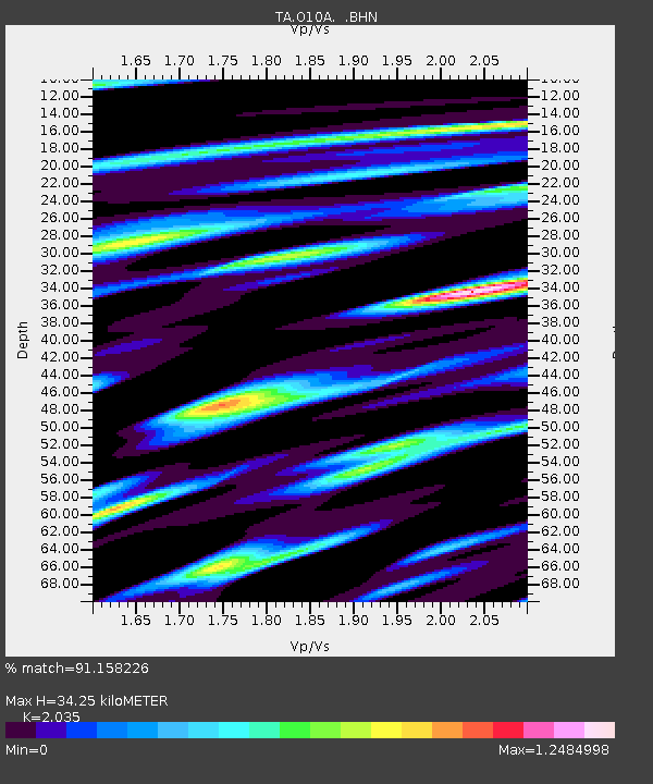
| Estimated Moho Depth: |
34.25 km |
| Estimated Crust Vp/Vs: |
2.04 |
| Assumed Crust Vp: |
6.276 km/s |
| Estimated Crust Vs: |
3.084 km/s |
| Estimated Crust Poisson's Ratio: |
0.34 |
|
| Radial Match: |
91.158226 % |
| Radial Bump: |
400 |
| Transverse Match: |
82.288574 % |
| Transverse Bump: |
400 |
| SOD ConfigId: |
2665 |
| Insert Time: |
2010-03-07 03:57:41.310 +0000 |
| GWidth: |
2.5 |
| Max Bumps: |
400 |
| Tol: |
0.001 |
|

Signal To Noise
| Channel | StoN | STA | LTA |
| TA:O10A: :BHN:20061001T09:15:52.825005Z | 2.4686368 | 2.776999E-7 | 1.124912E-7 |
| TA:O10A: :BHE:20061001T09:15:52.825005Z | 1.81465 | 2.2775292E-7 | 1.255079E-7 |
| TA:O10A: :BHZ:20061001T09:15:52.825005Z | 4.451563 | 5.5506695E-7 | 1.2469035E-7 |
| Arrivals |
| Ps | 5.9 SECOND |
| PpPs | 16 SECOND |
| PsPs/PpSs | 22 SECOND |


