You are here: Home > Network List > TA - USArray Transportable Network (new EarthScope stations) Stations List
> Station O10A Cortez Mining, Crescent City, NV, USA > Earthquake Result Viewer
O10A Cortez Mining, Crescent City, NV, USA - Earthquake Result Viewer
| Earthquake location: |
Near East Coast Of Kamchatka |
| Earthquake latitude/longitude: |
51.1/157.5 |
| Earthquake time(UTC): |
2006/08/24 (236) 21:50:36 GMT |
| Earthquake Depth: |
43 km |
| Earthquake Magnitude: |
5.9 MB, 6.2 MS, 6.5 MW, 6.5 MW |
| Earthquake Catalog/Contributor: |
WHDF/NEIC |
|
| Network: |
TA USArray Transportable Network (new EarthScope stations) |
| Station: |
O10A Cortez Mining, Crescent City, NV, USA |
| Lat/Lon: |
40.29 N/116.50 W |
| Elevation: |
1470 m |
|
| Distance: |
57.7 deg |
| Az: |
64.493 deg |
| Baz: |
311.995 deg |
| Ray Param: |
0.06322332 |
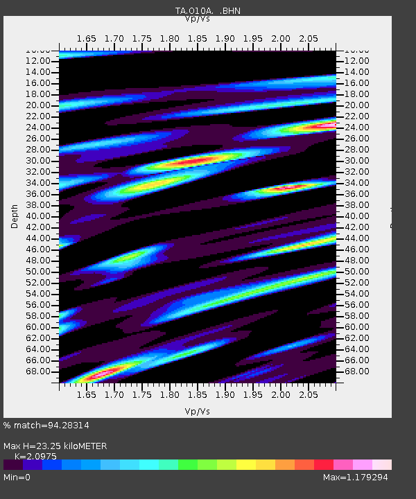
| Estimated Moho Depth: |
23.25 km |
| Estimated Crust Vp/Vs: |
2.10 |
| Assumed Crust Vp: |
6.276 km/s |
| Estimated Crust Vs: |
2.992 km/s |
| Estimated Crust Poisson's Ratio: |
0.35 |
|
| Radial Match: |
94.28314 % |
| Radial Bump: |
400 |
| Transverse Match: |
81.306465 % |
| Transverse Bump: |
400 |
| SOD ConfigId: |
2665 |
| Insert Time: |
2010-03-07 03:57:48.653 +0000 |
| GWidth: |
2.5 |
| Max Bumps: |
400 |
| Tol: |
0.001 |
|
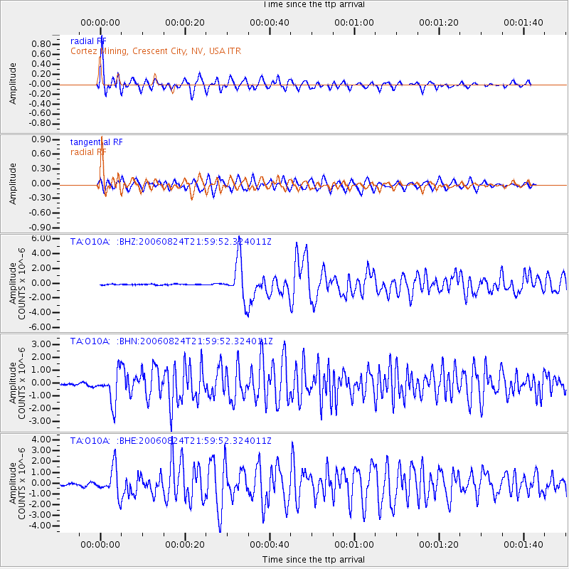
Signal To Noise
| Channel | StoN | STA | LTA |
| TA:O10A: :BHN:20060824T21:59:52.324011Z | 13.0636635 | 1.2691726E-6 | 9.7152885E-8 |
| TA:O10A: :BHE:20060824T21:59:52.324011Z | 16.500439 | 1.3484564E-6 | 8.172245E-8 |
| TA:O10A: :BHZ:20060824T21:59:52.324011Z | 52.208282 | 2.879397E-6 | 5.515211E-8 |
| Arrivals |
| Ps | 4.2 SECOND |
| PpPs | 11 SECOND |
| PsPs/PpSs | 15 SECOND |


