You are here: Home > Network List > AK - Alaska Regional Network Stations List
> Station BESE Bessie Mountain > Earthquake Result Viewer
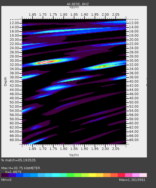
BESE Bessie Mountain - Earthquake Result Viewer
| Earthquake location: |
Fiji Islands Region |
| Earthquake latitude/longitude: |
-20.4/-178.4 |
| Earthquake time(UTC): |
2019/09/01 (244) 15:54:20 GMT |
| Earthquake Depth: |
617 km |
| Earthquake Magnitude: |
6.5 Mi |
| Earthquake Catalog/Contributor: |
NEIC PDE/at |
|
| Network: |
AK Alaska Regional Network |
| Station: |
BESE Bessie Mountain |
| Lat/Lon: |
58.58 N/134.85 W |
| Elevation: |
870 m |
|
| Distance: |
86.5 deg |
| Az: |
21.197 deg |
| Baz: |
220.35 deg |
| Ray Param: |
0.04219966 |
| Estimated Moho Depth: |
30.75 km |
| Estimated Crust Vp/Vs: |
1.70 |
| Assumed Crust Vp: |
6.566 km/s |
| Estimated Crust Vs: |
3.868 km/s |
| Estimated Crust Poisson's Ratio: |
0.23 |
|
| Radial Match: |
85.193535 % |
| Radial Bump: |
400 |
| Transverse Match: |
68.43914 % |
| Transverse Bump: |
400 |
| SOD ConfigId: |
19053131 |
| Insert Time: |
2019-09-15 15:56:45.442 +0000 |
| GWidth: |
2.5 |
| Max Bumps: |
400 |
| Tol: |
0.001 |
|

Signal To Noise
| Channel | StoN | STA | LTA |
| AK:BESE: :BHZ:20190901T16:05:27.607971Z | 12.054822 | 1.343427E-6 | 1.1144313E-7 |
| AK:BESE: :BHN:20190901T16:05:27.607971Z | 3.6032295 | 3.2124402E-7 | 8.915446E-8 |
| AK:BESE: :BHE:20190901T16:05:27.607971Z | 3.7788742 | 3.5117463E-7 | 9.2931025E-8 |
| Arrivals |
| Ps | 3.3 SECOND |
| PpPs | 12 SECOND |
| PsPs/PpSs | 16 SECOND |


