You are here: Home > Network List > CC - Cascade Chain Volcano Monitoring Stations List
> Station SWF2 Southwest Flank moved down hill, Mt. St. Helens, WA > Earthquake Result Viewer
SWF2 Southwest Flank moved down hill, Mt. St. Helens, WA - Earthquake Result Viewer
| Earthquake location: |
Fiji Islands Region |
| Earthquake latitude/longitude: |
-20.4/-178.4 |
| Earthquake time(UTC): |
2019/09/01 (244) 15:54:20 GMT |
| Earthquake Depth: |
617 km |
| Earthquake Magnitude: |
6.5 Mi |
| Earthquake Catalog/Contributor: |
NEIC PDE/at |
|
| Network: |
CC Cascade Chain Volcano Monitoring |
| Station: |
SWF2 Southwest Flank moved down hill, Mt. St. Helens, WA |
| Lat/Lon: |
46.18 N/122.22 W |
| Elevation: |
1548 m |
|
| Distance: |
83.5 deg |
| Az: |
35.524 deg |
| Baz: |
231.667 deg |
| Ray Param: |
0.044301767 |
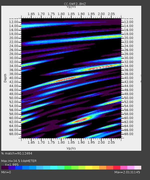
| Estimated Moho Depth: |
34.5 km |
| Estimated Crust Vp/Vs: |
2.00 |
| Assumed Crust Vp: |
6.566 km/s |
| Estimated Crust Vs: |
3.291 km/s |
| Estimated Crust Poisson's Ratio: |
0.33 |
|
| Radial Match: |
90.12494 % |
| Radial Bump: |
400 |
| Transverse Match: |
85.785194 % |
| Transverse Bump: |
398 |
| SOD ConfigId: |
19053131 |
| Insert Time: |
2019-09-15 15:59:16.053 +0000 |
| GWidth: |
2.5 |
| Max Bumps: |
400 |
| Tol: |
0.001 |
|

Signal To Noise
| Channel | StoN | STA | LTA |
| CC:SWF2: :BHZ:20190901T16:05:13.094971Z | 3.0670404 | 3.7894497E-7 | 1.2355396E-7 |
| CC:SWF2: :BHN:20190901T16:05:13.094971Z | 1.0337598 | 1.948896E-7 | 1.8852502E-7 |
| CC:SWF2: :BHE:20190901T16:05:13.094971Z | 0.87005424 | 2.5850233E-7 | 2.9711057E-7 |
| Arrivals |
| Ps | 5.3 SECOND |
| PpPs | 15 SECOND |
| PsPs/PpSs | 21 SECOND |


