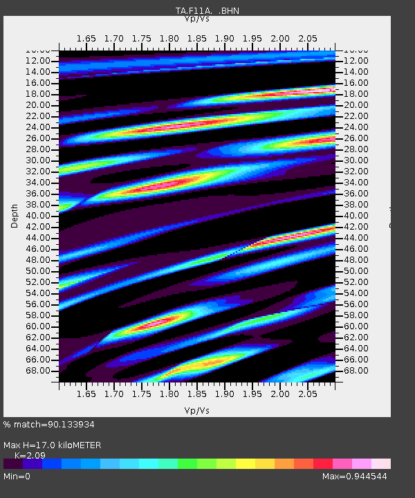
F11A Grangeville, ID, USA - Earthquake Result Viewer
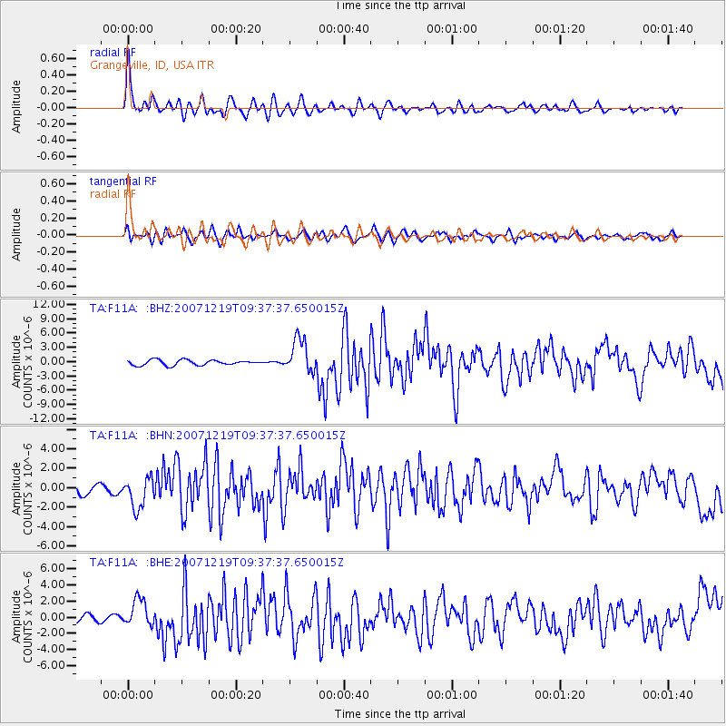
Earthquake location: Andreanof Islands, Aleutian Is.
Earthquake latitude/longitude: 51.4/-179.5
Earthquake time(UTC): 2007/12/19 (353) 09:30:27 GMT
Earthquake Depth: 29 km
Earthquake Magnitude: 6.4 MB, 7.1 MS, 7.1 MW, 7.0 MW
Earthquake Catalog/Contributor: WHDF/NEIC
Network: TA USArray Transportable Network (new EarthScope stations)
Station: F11A Grangeville, ID, USA
Lat/Lon: 45.89 N/116.15 W
Elevation: 1186 m
Distance: 41.1 deg
Az: 71.845 deg
Baz: 301.47 deg
Ray Param: 0.07396278
Estimated Moho Depth: 17.0 km
Estimated Crust Vp/Vs: 2.09
Assumed Crust Vp: 6.571 km/s
Estimated Crust Vs: 3.144 km/s
Estimated Crust Poisson's Ratio: 0.35
Radial Match: 90.133934 %
Radial Bump: 400
Transverse Match: 76.43721 %
Transverse Bump: 400
SOD ConfigId: 2564
Insert Time: 2010-03-07 03:59:22.879 +0000
GWidth: 2.5
Max Bumps: 400
Tol: 0.001

Signal To Noise

ChannelStoNSTALTA
TA:F11A: :BHN:20071219T09:37:37.650015Z2.8617241.5695347E-65.4845776E-7
TA:F11A: :BHE:20071219T09:37:37.650015Z3.04956221.7065518E-65.596055E-7
TA:F11A: :BHZ:20071219T09:37:37.650015Z6.51641943.588165E-65.5063447E-7
Arrivals
Ps3.0 SECOND
PpPs7.5 SECOND
PsPs/PpSs11 SECOND