You are here: Home > Network List > TA - USArray Transportable Network (new EarthScope stations) Stations List
> Station F11A Grangeville, ID, USA > Earthquake Result Viewer
F11A Grangeville, ID, USA - Earthquake Result Viewer
| Earthquake location: |
South Of Fiji Islands |
| Earthquake latitude/longitude: |
-26.0/-177.5 |
| Earthquake time(UTC): |
2007/12/09 (343) 07:28:20 GMT |
| Earthquake Depth: |
152 km |
| Earthquake Magnitude: |
7.0 MB, 7.8 MW, 7.7 MW |
| Earthquake Catalog/Contributor: |
WHDF/NEIC |
|
| Network: |
TA USArray Transportable Network (new EarthScope stations) |
| Station: |
F11A Grangeville, ID, USA |
| Lat/Lon: |
45.89 N/116.15 W |
| Elevation: |
1186 m |
|
| Distance: |
90.6 deg |
| Az: |
37.809 deg |
| Baz: |
232.176 deg |
| Ray Param: |
0.041628968 |
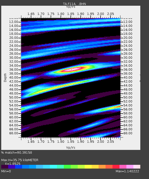
| Estimated Moho Depth: |
35.75 km |
| Estimated Crust Vp/Vs: |
1.85 |
| Assumed Crust Vp: |
6.571 km/s |
| Estimated Crust Vs: |
3.547 km/s |
| Estimated Crust Poisson's Ratio: |
0.29 |
|
| Radial Match: |
90.39158 % |
| Radial Bump: |
400 |
| Transverse Match: |
87.622375 % |
| Transverse Bump: |
400 |
| SOD ConfigId: |
2564 |
| Insert Time: |
2010-03-07 03:59:25.500 +0000 |
| GWidth: |
2.5 |
| Max Bumps: |
400 |
| Tol: |
0.001 |
|
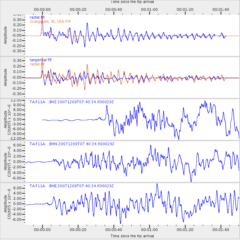
Signal To Noise
| Channel | StoN | STA | LTA |
| TA:F11A: :BHN:20071209T07:40:34.600029Z | 1.1189791 | 1.3552014E-7 | 1.2111052E-7 |
| TA:F11A: :BHE:20071209T07:40:34.600029Z | 1.4222957 | 2.8705654E-7 | 2.0182621E-7 |
| TA:F11A: :BHZ:20071209T07:40:34.600029Z | 3.2226927 | 7.20301E-7 | 2.2350906E-7 |
| Arrivals |
| Ps | 4.7 SECOND |
| PpPs | 15 SECOND |
| PsPs/PpSs | 20 SECOND |


