You are here: Home > Network List > TA - USArray Transportable Network (new EarthScope stations) Stations List
> Station F11A Grangeville, ID, USA > Earthquake Result Viewer
F11A Grangeville, ID, USA - Earthquake Result Viewer

| Earthquake location: |
East Of Kuril Islands |
| Earthquake latitude/longitude: |
46.0/154.2 |
| Earthquake time(UTC): |
2007/10/25 (298) 13:50:02 GMT |
| Earthquake Depth: |
10 km |
| Earthquake Magnitude: |
6.0 MB, 5.7 MS, 6.1 MW, 5.9 MW |
| Earthquake Catalog/Contributor: |
WHDF/NEIC |
|
| Network: |
TA USArray Transportable Network (new EarthScope stations) |
| Station: |
F11A Grangeville, ID, USA |
| Lat/Lon: |
45.89 N/116.15 W |
| Elevation: |
1186 m |
|
| Distance: |
58.9 deg |
| Az: |
54.652 deg |
| Baz: |
305.524 deg |
| Ray Param: |
0.06254004 |
| Estimated Moho Depth: |
50.0 km |
| Estimated Crust Vp/Vs: |
2.00 |
| Assumed Crust Vp: |
6.571 km/s |
| Estimated Crust Vs: |
3.285 km/s |
| Estimated Crust Poisson's Ratio: |
0.33 |
|
| Radial Match: |
83.26276 % |
| Radial Bump: |
400 |
| Transverse Match: |
74.412704 % |
| Transverse Bump: |
400 |
| SOD ConfigId: |
2564 |
| Insert Time: |
2010-03-07 03:59:29.915 +0000 |
| GWidth: |
2.5 |
| Max Bumps: |
400 |
| Tol: |
0.001 |
|
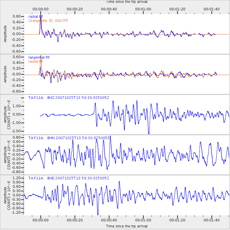
Signal To Noise
| Channel | StoN | STA | LTA |
| TA:F11A: :BHN:20071025T13:59:30.625005Z | 1.7085893 | 2.8337482E-7 | 1.658531E-7 |
| TA:F11A: :BHE:20071025T13:59:30.625005Z | 1.6408203 | 2.3758707E-7 | 1.4479774E-7 |
| TA:F11A: :BHZ:20071025T13:59:30.625005Z | 8.149725 | 6.0824306E-7 | 7.463357E-8 |
| Arrivals |
| Ps | 8.0 SECOND |
| PpPs | 22 SECOND |
| PsPs/PpSs | 30 SECOND |


