You are here: Home > Network List > TS - TERRAscope (Southern California Seismic Network) Stations List
> Station MLAC Mammoth Lakes, California, USA > Earthquake Result Viewer
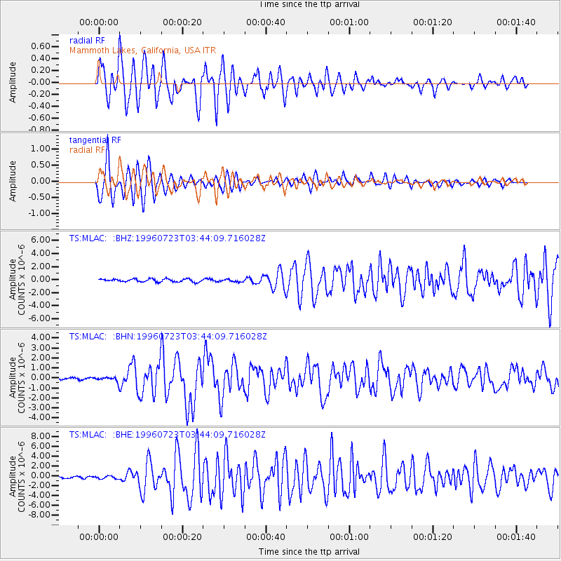
MLAC Mammoth Lakes, California, USA - Earthquake Result Viewer
*The percent match for this event was below the threshold and hence no stack was calculated.
| Earthquake location: |
South Of Fiji Islands |
| Earthquake latitude/longitude: |
-26.8/-177.2 |
| Earthquake time(UTC): |
1996/07/23 (205) 03:32:12 GMT |
| Earthquake Depth: |
33 km |
| Earthquake Magnitude: |
5.8 MB, 6.4 MS, 6.5 UNKNOWN, 6.5 MW |
| Earthquake Catalog/Contributor: |
WHDF/NEIC |
|
| Network: |
TS TERRAscope (Southern California Seismic Network) |
| Station: |
MLAC Mammoth Lakes, California, USA |
| Lat/Lon: |
37.63 N/118.83 W |
| Elevation: |
2170 m |
|
| Distance: |
84.3 deg |
| Az: |
42.795 deg |
| Baz: |
229.92 deg |
| Ray Param: |
$rayparam |
*The percent match for this event was below the threshold and hence was not used in the summary stack. |
|
| Radial Match: |
76.69232 % |
| Radial Bump: |
400 |
| Transverse Match: |
79.965515 % |
| Transverse Bump: |
400 |
| SOD ConfigId: |
4480 |
| Insert Time: |
2010-02-26 14:27:53.407 +0000 |
| GWidth: |
2.5 |
| Max Bumps: |
400 |
| Tol: |
0.001 |
|
Signal To Noise
| Channel | StoN | STA | LTA |
| TS:MLAC: :BHN:19960723T03:44:09.716028Z | 3.4524026 | 2.7681045E-7 | 8.017908E-8 |
| TS:MLAC: :BHE:19960723T03:44:09.716028Z | 1.4934945 | 2.8013773E-7 | 1.8757197E-7 |
| TS:MLAC: :BHZ:19960723T03:44:09.716028Z | 0.80939955 | 1.78705E-7 | 2.207871E-7 |
| Arrivals |
| Ps | |
| PpPs | |
| PsPs/PpSs | |


