You are here: Home > Network List > TA - USArray Transportable Network (new EarthScope stations) Stations List
> Station F11A Grangeville, ID, USA > Earthquake Result Viewer
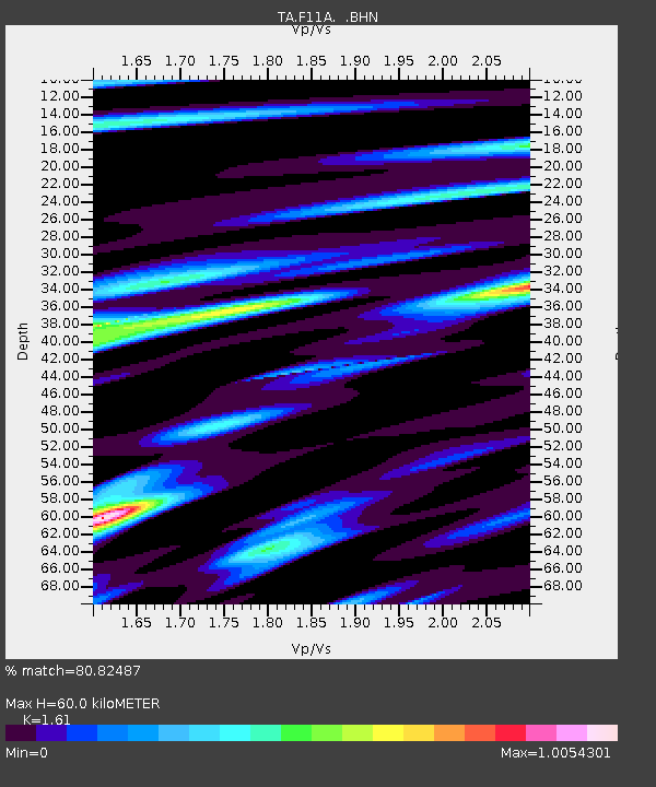
F11A Grangeville, ID, USA - Earthquake Result Viewer
| Earthquake location: |
South Of Mariana Islands |
| Earthquake latitude/longitude: |
10.5/145.7 |
| Earthquake time(UTC): |
2007/09/30 (273) 02:08:30 GMT |
| Earthquake Depth: |
14 km |
| Earthquake Magnitude: |
6.4 MB, 7.1 MS, 6.9 MW, 6.9 MW |
| Earthquake Catalog/Contributor: |
WHDF/NEIC |
|
| Network: |
TA USArray Transportable Network (new EarthScope stations) |
| Station: |
F11A Grangeville, ID, USA |
| Lat/Lon: |
45.89 N/116.15 W |
| Elevation: |
1186 m |
|
| Distance: |
88.2 deg |
| Az: |
43.773 deg |
| Baz: |
283.035 deg |
| Ray Param: |
0.042776886 |
| Estimated Moho Depth: |
60.0 km |
| Estimated Crust Vp/Vs: |
1.61 |
| Assumed Crust Vp: |
6.571 km/s |
| Estimated Crust Vs: |
4.081 km/s |
| Estimated Crust Poisson's Ratio: |
0.19 |
|
| Radial Match: |
80.82487 % |
| Radial Bump: |
400 |
| Transverse Match: |
71.10094 % |
| Transverse Bump: |
400 |
| SOD ConfigId: |
2564 |
| Insert Time: |
2010-03-07 03:59:31.524 +0000 |
| GWidth: |
2.5 |
| Max Bumps: |
400 |
| Tol: |
0.001 |
|

Signal To Noise
| Channel | StoN | STA | LTA |
| TA:F11A: :BHN:20070930T02:20:48.974016Z | 1.0216396 | 1.932168E-7 | 1.8912422E-7 |
| TA:F11A: :BHE:20070930T02:20:48.974016Z | 1.0590906 | 1.863845E-7 | 1.7598542E-7 |
| TA:F11A: :BHZ:20070930T02:20:48.974016Z | 2.1763942 | 3.488203E-7 | 1.6027442E-7 |
| Arrivals |
| Ps | 5.7 SECOND |
| PpPs | 23 SECOND |
| PsPs/PpSs | 29 SECOND |


