You are here: Home > Network List > TA - USArray Transportable Network (new EarthScope stations) Stations List
> Station F11A Grangeville, ID, USA > Earthquake Result Viewer
F11A Grangeville, ID, USA - Earthquake Result Viewer
| Earthquake location: |
Solomon Islands |
| Earthquake latitude/longitude: |
-9.8/159.5 |
| Earthquake time(UTC): |
2007/08/16 (228) 08:39:27 GMT |
| Earthquake Depth: |
10 km |
| Earthquake Magnitude: |
6.1 MB, 6.7 MS, 6.4 MW |
| Earthquake Catalog/Contributor: |
WHDF/NEIC |
|
| Network: |
TA USArray Transportable Network (new EarthScope stations) |
| Station: |
F11A Grangeville, ID, USA |
| Lat/Lon: |
45.89 N/116.15 W |
| Elevation: |
1186 m |
|
| Distance: |
93.1 deg |
| Az: |
44.117 deg |
| Baz: |
259.174 deg |
| Ray Param: |
0.041329008 |
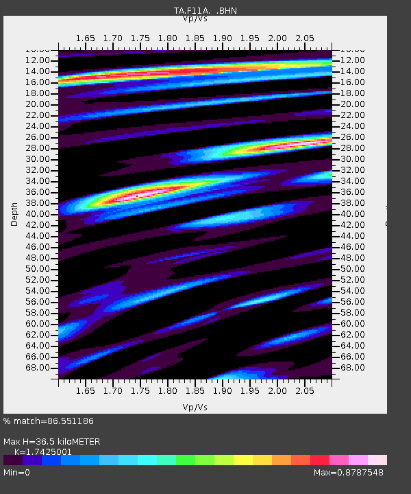
| Estimated Moho Depth: |
36.5 km |
| Estimated Crust Vp/Vs: |
1.74 |
| Assumed Crust Vp: |
6.571 km/s |
| Estimated Crust Vs: |
3.771 km/s |
| Estimated Crust Poisson's Ratio: |
0.25 |
|
| Radial Match: |
86.551186 % |
| Radial Bump: |
400 |
| Transverse Match: |
84.16936 % |
| Transverse Bump: |
400 |
| SOD ConfigId: |
2564 |
| Insert Time: |
2010-03-07 03:59:46.303 +0000 |
| GWidth: |
2.5 |
| Max Bumps: |
400 |
| Tol: |
0.001 |
|

Signal To Noise
| Channel | StoN | STA | LTA |
| TA:F11A: :BHN:20070816T08:52:09.899001Z | 1.3573124 | 4.634695E-8 | 3.414612E-8 |
| TA:F11A: :BHE:20070816T08:52:09.899001Z | 2.9346054 | 9.6910384E-8 | 3.3023312E-8 |
| TA:F11A: :BHZ:20070816T08:52:09.899001Z | 5.4204082 | 2.2104004E-7 | 4.0779224E-8 |
| Arrivals |
| Ps | 4.2 SECOND |
| PpPs | 15 SECOND |
| PsPs/PpSs | 19 SECOND |


